Hurricane Michael
I'm surprised nobody is talking about this yet on here. Landfall looks to be at the panhandle of FL as a category 3 storm. Looks like we might see another couple of inches of rain from Michael Thursday into Friday. Unfortunately, the rain soaked areas down south will see at least 6 inches of rain.
 Calico696
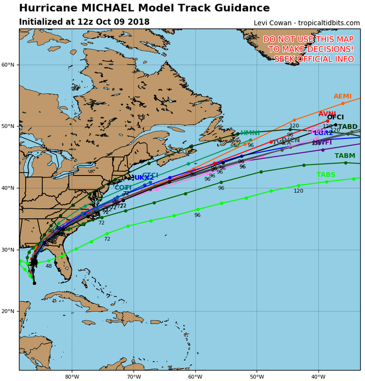
As of right now, Main models are tracking Michael south of our area. If it goes more north, then yes, 2-5 inches area wide, but right now I wouldn't really bet on that happening maybe 30 percent chance (that's me being generous) IMO based on current models and data.
Either way bad news for the Carolina's, as more water will exacerbate the situation down there, especially with weakened damns and some areas having standing water.
 gzellf
Looks like the center should be to the east of me, but will hit Bryan and Skippy.
As of now, prediction is 2-4" of rain in my area, and 4-6" in theirs.
 Mark Mc.
  iJay
iJay Mikey is in the prime spot in the deep warm Loop Current.
We've been down this road before with Tropical systems and rapid intensification in this area of the Gulf:
https://en.wikipedia.org/wiki/Loop_Current
 Lenny Rock
 The surf is really getting rough in Panama City. Here's a link to some live webcams.
https://www.visitpanamacitybeach.com/webcam
 ianimal
 Geez, Weather Channel is showing it at 145 MPH @ Cat 4 and it's within hours of landfall. Not looking good and my hometown in Georgia is going to get a severe beatdown and my friends in Coastal NC are going to end up just getting hammered again. The only good thing about it is that it's moving more quickly than Florence was, so it will get out of there more quickly. Tiny blessings, but it's all we're getting... .
 Phil D.
 Here's one that is working, for now.
https://www.earthcam.com/events/extremeweather
Hopefully NC will get a breeze by and the water will reach flood levels.
The area to the right of the eye on the panhandle for storm surge looks huge and wide. So it will wrap around the panhandle curve. Hopefully Panama City might get to left of the eye. Doesn't look good though; think folks may be not able to return to the coast for days, if not weeks.
IMO, we really need to pollute less. It would be really nice to have some sort of global agreement to do that.
 strangerdanger
 Hope the Flora-Bama survives... one of my favorite bars of all time. The Redneck Riviera is vastly under-rated, lol.
Based on home prices, not to much so last time I looked. At least on the coast.
Conditions are deteriorating very rapidly. The Earthcam cam link is still working.
Weather Channel now showing speed's at 150 MPH, up from the earlier 145. If it hits 157 MPH it will be a Cat 5 when it makes landfall. They're also saying that the storm surge may reach as much as 20 miles inland. This is looking worse and worse as time goes on.
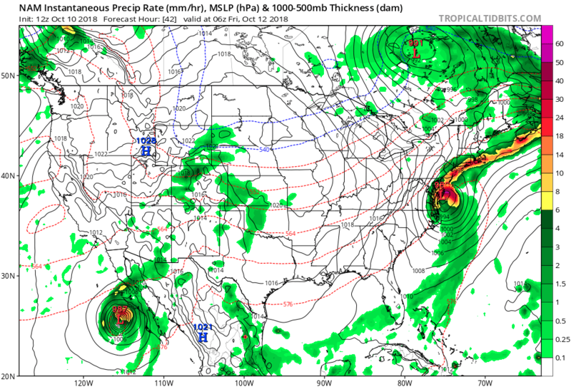
Storm is still strengthening. Some parts showed pressures of 919.9, which is crazy low. The warm bath water of the gulf really fueled this beast. I wont be surprised if you see reports of storm surge above 20 ft. Anyone who decided to sty behind and ride it out: Godspeed, especially if they're in a mobile trailer or something (seems to be a trend in Florida)...those things will become splinters in this storm.
We'll probably see rain up here come Friday. One of the weather models shows a lot of rain ahead of the storm, called a Predecessor Rain Event. We'll see if the heavier rains get to us out in NW jersey based on how far North Michael decides to go.
Now almost Cat 5 - 155 MPH & 919mb at landfall.
Besides watching the Weather channel, which has continuous live coverage, I Usally watch:
https://www.youtube.com/user/LiveStormsNetwork
Calico, that particular camera is located at Treasure Island, near Tampa... they aren't getting anywhere near the brunt of it.
Edit - My bad, there's an available camera at WaterSound, which is on the panhandle just east of PCB. Now that I type this, it also went dark...
https://www.youtube.com/watch?time_continue=4&v=13UoLG4assM
to give an idea of the damages down there.
Commenting is no longer available.