Jan 16 Storm?
Lots of buzz starting about 3 potential coastal storms/nor'easters in the next 10 or so days.
I'd like to keep an eye on who is forecasting what/when. I've seen a difference from yesterday to today (going from big snow to no snow).
So, today, Jan 10, here is what various sources are predicting.
weather.com: 30% chance of am snowshowers
accuweather: cloudy
darksky: mostly cloudy
WeatherNJ (Fb): (Jan 9 Not a forecast, a comment: wintry storm signal watching (for Sunday and the next week).
Weatherboy (Fb): (Jan 9) Not a forecast, a comment: We wouldn't be surprised if Philly, New York City, and Boston (and surrounding areas) saw blizzard conditions before the end of the month. Perhaps even in less than 10 days.
Feel free to play along. Add your favorite sources. Let's update daily to see where they all go.
https://www.tropicaltidbits.com/analysis/models/
I use this to see what's coming. odds are better for something on the 18th and then maybe the 22nd, but only if it's cold enough
 Ser positivo
I've posted it here many times. I'm sticking with my weather rock. "Rock Never Wrong".
LOL
 Greg
Greg New models have been released … these storms at this time are going to miss us. But we need to keep an eye on them but by Wednesday we will have a better idea what they are going to do.
 LibertyThinker
 Greg, some of the Facebook amateurs are now using your rock as opposed to actually *fore*casting. Fear of being wrong. :-)
Liberty Thinker - you just said all 3 storms, 6-10 days out are now off the coast? Now that’s ambitious forecasting!
 Philliesman
 4 of 4 - from the models this morning the storm that on the 16th is looking like a miss…. I won’t even try to figure out what going happen any further out …. Again on Wednesday we can look at models again and give the forum our findings
 Phil D.
  ianimal
 Jan 11
The new speculation is the possibility of the snow coming the 16/17.
weather.com: mostly cloudy both days
accuweather: partly sunny Sunday, cloudy Monday
darksky: Sunday nothing: ***Monday Snow 5 - 9 in***
WeatherNJ (Fb): (Jan 10 Not a forecast, a comment: The Sunday system is the current one to watch..."article" coming today).
Weatherboy (Fb): Nothing new.
All I am going to say is that I was married on January 18 in 1992. Every single 1/18 following brought a snowstorm. The storms stopped after my July 2018 divorce.
Coincidence? Haha!
 LVMomOfBoys
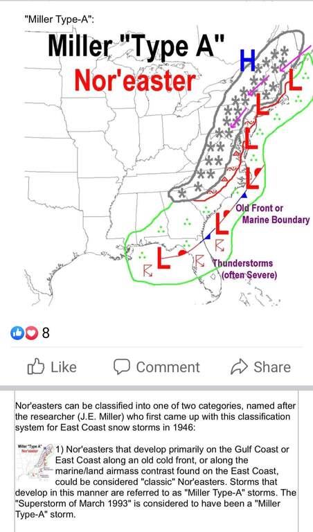
 maja2
maja2 National Weather Service
Sunday
Mostly sunny, with a high near 27.
Sunday Night
A chance of snow. Partly cloudy, with a low around 15. Chance of precipitation is 30%.
M.L.King Day
A chance of snow. Partly sunny, with a high near 34. Chance of precipitation is 40%.
 CBGB
CBGB LVMomOfBoys - LOL!
maja2- i’ve seen that Miller A classification referenced for Monday, as well. Where did you see it?
We need to keep an eye on the storm coming Monday Jan 17th … I am waiting on the newest models to be released .
Focus is on Monday now.
weather.com: rain/snow
accuweather: Considerable cloudiness with snow possible
darksky: Sunday Heavy snow (1–3 in.) and windy overnight.: Monday Rain & 52 degrees!
WeatherNJ (Fb): (Jan 11 Not a forecast, a comment: ). "watching models"; Was supposed to post a story last night. Now says it'll be tonight.
Weatherboy (Fb): Blog post written for 5th graders, not impressed: https://weatherboy.com/forecast-models-suggest-major-storm-is-the-blizzard-of-22-on-the-way/
Mark Margavage (I can't tell where in PA he is located): "I expect a high impact Miller "Type A" Nor'Easter to impact much of my forecast area Sunday into Monday."
EasternPA Weather Authority: Models have shifted north. Some will get big snow, some rain. TBD. Their video is very good: https://youtu.be/Ury4n6eCM0E
Mark Margavage is the only one sticking out his neck to make a prediction at 5 -6 days out. Like the other, he's questioning rain vs snow depending on location. Fair enough.
I'm enjoying this. I'm impressed with EPAWA. Unimpressed with Weatherboy. Following the others with interest (WeatherNJ) or disdain (Dark Sky and the other commercial sites).
Question: how far ahead is FOREcasting? At what point should we expect actual estimates?
 Darrin
 5 days out is when you can start narrowing it down. Now narrow down doesn't mean certainty though. I believe with this one they were waiting for another storm to hit NE today to get more data.
 Yesimpc
 Well that changed quickly. Now 92% chance of snow and 7” from weather underground
This storm all depends on the track and how far off the coast it is … we won’t get a good prediction until Saturday.
I don't think we will get a good "prediction" until Monday at 6pm....the weather predictions have been totally off for the past few years
The Sunday night into Monday storm will be a mix of snow - ice - rain … amounts are hard to predict due to when it the change over occurs .. most outlets are calling for 3 - 6 inches of snow… Saturday evening we should have the track details - timing and details of the storm will become clearer …. Note…. Any change in the track could change everything.
 Me2be
Me2be Storm moved so now u can look at it starting around 830pm to 10:30 pm
Snow and sleet in our area most snow we will see is going to be 1 to 2.5 inches. 3 tops
The wind will be 25-30 mph gusts and tonight very cold. Warming up Sunday night around midnight
Update to storm
Looking like it may start a little sooner around
6pm to 9 pm and be changed over to all rain by 2 am……by 3 am it is much warmer and the ice threat is gone. So my prediction may be closer to 1-2 inches tops With the rain following it will quickly melt. Behind the storm you may see some snow showers but nothing major
I have no meteorological training, either - so, I'll just guess.
Starts at 7:32 pm as snow, white flakes. You'll be cold. Snows until 4:40 am on Monday. You'll shovel at 8 am after coffee. It'll start be icy out. There will be 3.7 inches in Hackettstown if you measure correctly with your son's ruler. You forgot your coffee and reheat it. You realize you have off from work for the holiday and shoveled for nothing.
Anyway - It's all up to Mother Nature. Just be safe no matter what you do.
Yeah planning on this one to take care of itself- the switch over to rain will hopefully get rid of it all by Monday evening...
 JeffersonRepub
 I bought gas for my generator…. Just in case… the ice then rain and wind knock out the power.
Is the forecast pretty much set or is there still a chance for a larger snow total?
...WINTER WEATHER ADVISORY REMAINS IN EFFECT FROM 6 PM THISEVENING TO 1 AM EST MONDAY...
* WHAT...Mixed precipitation expected. Total snow accumulations of 1 to 3 inches and ice accumulations of up to one tenth of an inch. Winds gusting as high as 45 mph.
* WHERE...Portions of northern and northwest New Jersey and east central and southeast Pennsylvania.
* WHEN...From 6 PM this evening to 1 AM EST Monday.
Well, I just got a notification we could be getting up to 3", starting at 3am (jan 20)... so maybe you'll have a little more to help with the snowmobiles LOL
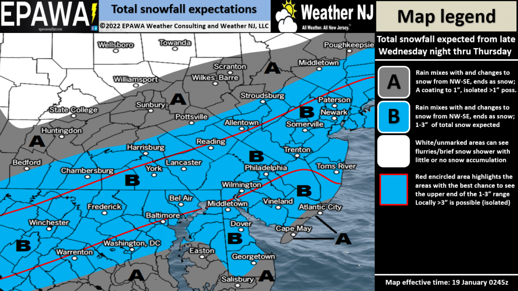
Here's EPAWA's call... we're right on the line where 3" could be a possibility.
What really P's me off is the temps.... this rain will turn to snow, and everything will stay frozen for DAYS do to the deep freeze coming. My patio and back yard are already so icy I'm afraid to let my dog out... one slip could be a trip to the vet! And today's "cloudy 41 windy" likely won't melt much...
NWS still has us at less than an inch total between tonight and tomorrow. I think they're expecting it to start as rain...
Yeah, rain then snow... but with the Uber-low temps 28F tonite, but DROPPING as tomorrow comes on), I expect some of the rain to freeze as ice. With snow on top. Fun.
 Jrsemom
 Leave a Reply
To comment on this topic, fill out the form below. If you would like to comment directly to one person, you may click on the envelope next to the posters name if they provided their email.