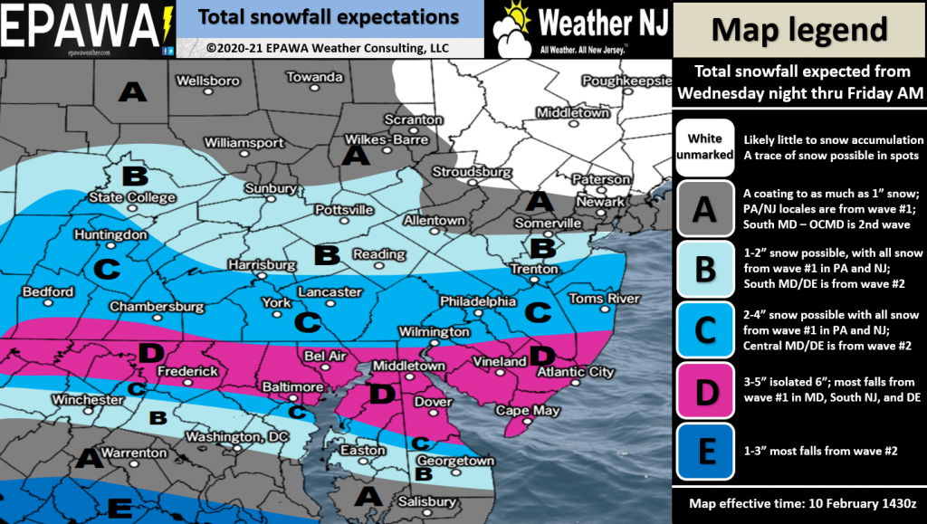
Snow 2020 -2021
Insane!!!! Can't believe it! I don't think it was last long - flakes are really big but it sure is pretty out.
 Luca
Luca  thomasnj
 Snowing pretty heavily in Independence Twp. Ground is covered. Anyone know if this is supposed to last long? My trees have not lost their leaves at all, and I don't want limbs coming down or losing my power.
Is it snowing in H'town?
 Lonesome Dove
  GC
GC  OP
OP Early yet; like Bryan said, it depends on the snow line and that can still shift. Will be the pattern for much of this El Nino year.
Last night they predicted 28 and a warming trend by 4am; at 6am it was 26 and did not rise till 7 or 8. Just that kind of year.
 Strangerdanger
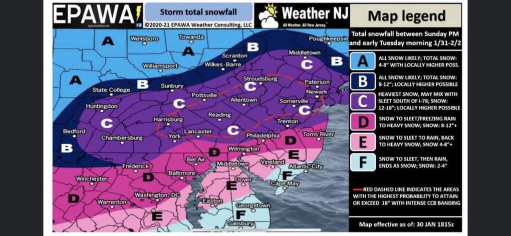
 They are talking big amounts for Wednesday as well as a 1-3" accumulation on Monday. My weather outlook has 12"+ here for Wednesday. EPAWA discusses it on his latest vid. https://www.youtube.com/watch?v=84SCHHSRIAg
Yeh models are on board with a big snowstorm. That being said 4 days out. Things can still change but you can certainly be cautiously optimistic at this point.
 Bryan_NC
 Thanks Bryan! I was going to NY Wednesday to say happy 91st to my father. Tuesday seems like a safer choice!
 maja2
maja2  3wbdwnj
 I agree Bryan this could be a big one... we will know more late Monday - Tuesday morning ... crossing my fingers for 2 feet !!!
 LibertyThinker
  coach
coach wow... for all you that love the snow I hope it happens for you and it lasts thru Christmas too ! I know I am missing snow since moving south. I loved the snow days and the 1 foot plus storms in Hackettstown
 Hockeymom115
 I personally could do without 1-2 feet. 1-2 inches sure. Feet no. Sorry to rain on the snow parade.
 CraftBeerBob
 Things still look great for a big snowstorm, Weds through Weds night at least.
Also Monday could be a bit messy with some minor accumulations.
NOAA has released a briefing for this storm:
https://www.weather.gov/media/phi/current_briefing.pdf
"For the Wednesday storm, the combination of gusty winds, significant snow, and high moisture content of the snow will have the potential to cause power outages and will likely impact at least the afternoon commute."
.WINTER STORM WATCH IN EFFECT FROM WEDNESDAY MORNING THROUGHTHURSDAY MORNING...
* WHAT...Heavy snow possible. Total snow accumulations of 12 inches or more possible.
* WHERE...Portions of the Poconos, Lehigh Valley, and northwest New Jersey.
* WHEN...From Wednesday morning through Thursday morning.
* IMPACTS...Travel could be very difficult. The hazardous conditions could impact the morning or evening commute.

 Mr. Resident
 I dunno bug, all of the models are in agreement for this storm, unlike other storms.
BRING ON THE SNOW!
Got all the snowmobiles running and up to par yesterday, looking forward to this snow hanging around through the weekend and hoping to get some riding in!
Stay safe out there guys!
 Darrin
 At least now I have a setup to work from home so I don't have to brave over a foot of snow just to go into the office...
Though if there are power outages, WFH won't be an option either...
 honestyseasy
 Get yourself a battery backup for your router, i have a APC 1500 and I get about 2 1/2 hours out of it powering 3 routers and a cell repeater.
Um, laptop?
Additionally, with my PC plugged into the battery backup I get 45 minutes of runtime, usually enough time to at least save and closeout what you were doing, or in some cases enough for power to be restored.
What about the power failure on comcasts lines?.. they are not powered like telco lines..they use commercial power
They do not send power down COAX like the phone company does. When I used to have cable, as long as the lines were still physically up we still had TV and internet.
We watched TV off a battery backup during sandy, cable was the only thing that remained during the storm.
Additionally, you can always use the hotspot feature on your phone or get a mifi if loosing actual internet is a common issue.
Your lucky your cable worked..I lost internet for 3 days in july while still having power
I think what Darrin is trying to say is that there are layers of connectivity that will hopefully remain in service. Yes, if the entire state of NJ loses power then you get a day off of work (even from home), but the chances of your house losing power, coax/cable lines coming down, and cell towers knocked out of commission simultaneously would probably require more than just a bit of snow (especially if the trees have already shed their leaves and there is no heavy wind predicted).
 Mark Mc.
 "You need to buy a UPS for the cell tower....DUH!"
I'd be surprised if cell towers (at least some of them) didn't have a big diesel generator for backup power.
Bryan... always good to see you, this time of year. I trust no other forecaster
 Maggie O'Donnell
  iJay
iJay  Calico696
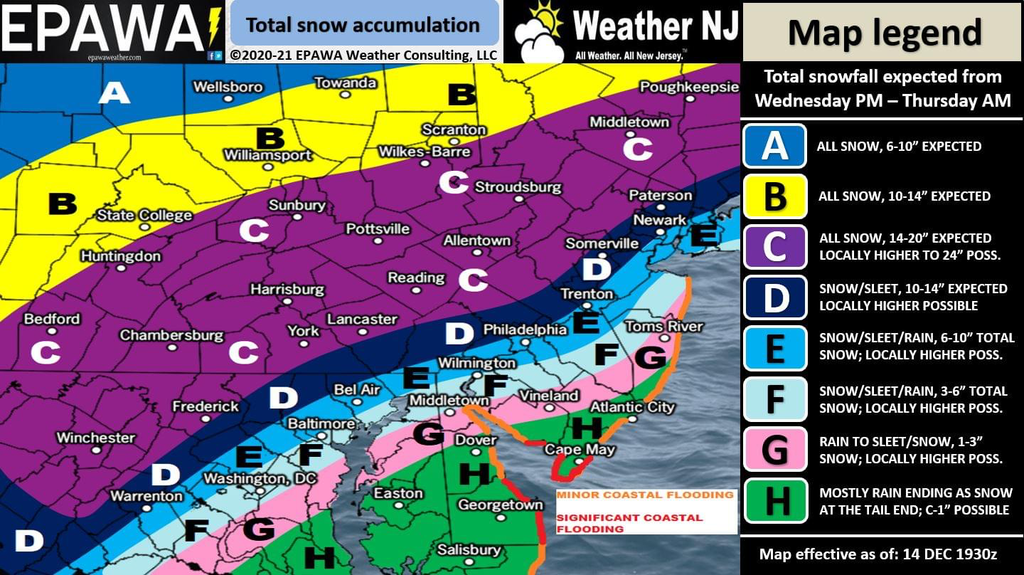
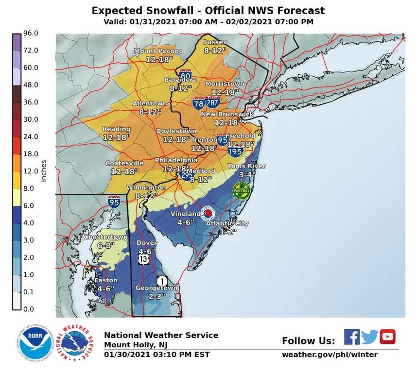
 Let's see. If I read NOAA right, we're getting 17 inches, winds up to 35mph. Starts Weds PM and runs through Thursday AM. About 10% chance right now of more, but mostly West or North of us. For us, There's a 60% chance of getting more than 12 inches, 90% chance of more than 6 inches so they are pretty confident in that 6-12 area with fair odds of getting more than 12.
So far, no ice, that's well South of us for now.
Next update probably tomorrow morning.
Issued By
Philadelphia - PA, US, National Weather Service
Affected Area
Portions of northern New Jersey and east central and northeast Pennsylvania
Description
...WINTER STORM WARNING IN EFFECT FROM 10 AM WEDNESDAY TO 10 AM EST THURSDAY...
WHAT...Heavy snow expected. Total snow accumulations of 20 to 24 inches. Winds gusting as high as 35 mph.
WHERE...Portions of northern New Jersey and east central and northeast Pennsylvania.
WHEN...From 10 AM Wednesday to 10 AM EST Thursday.
IMPACTS...Travel could be very difficult to impossible. The hazardous conditions could impact the evening commute on Wednesday and the morning commute on Thursday. The heavy snow could result in power outages.
ADDITIONAL DETAILS...Snow will move in southwest to northeast late Wednesday morning into the early afternoon. The snow could become heavy at times late Wednesday afternoon into Wednesday evening.
PRECAUTIONARY/PREPAREDNESS ACTIONS...
If you must travel, keep an extra flashlight, food, and water in your vehicle in case of an emergency.
@LiberyThinker
Got my generator prepped and ready, snow blower tuned and ready, extra salt, extra shovels and wood box fully stocked.
Guaranteed that this storm misses us.
 ChrisK
 As of this am, and generating the warning above, while calling for a range of 18 to 24, NOAA's pick is 22 for now, next update at 6pm. The last update called for 12 to 18, so trending is upwards.
Also, 10% chance of 22 inches, 50% chance of greater than 18. 86% chance of greater than 12.
So, doubtful it's a bust. Ice is still Phili to Freehold, at point .02, that's a glaze.
Wind may be the multiplier; hopefully stays on the coast.
I just got a text from WT OEM Washington Township Office of Emergency Management and they say 10"-15"...???
I have found, in recent years, EPAWA has better snow calls than the other sources. Altho NOAA isn't too bad either.
 JeffersonRepub
 Although the amounts differ somewhat, all sources agree it's going to be a doozy!! However, no one agrees on the start time. I have heard reports of it starting as early as 7 AM Wednesday all the way to 9 PM with many times in between and then going through the night into Thursday. Any opinions??
 Parental Unit
 I've followed NOAA briefing reports for the last 10 years or so... This is the first they have stated "Extensive and widespread severe property damage, life saving actions will be needed. Results in extreme disruptions to daily life."
What the hell is coming?
Some of the millenial weather forcasters have never experienced a Christmas snow in NJ... If we get alot of ice it wi be a disaster...if its just 2 feet of snow...wont do too much to trees with no leaves..if its a wet heavy snow it will be a witch to shovel..but life goes home..atleast most of us don't need to drive in it
Hmm... maybe I WILL go out and get an extra can of gas for the generator... just in case... getting power restored in recent years has been a FUBAR.
Start time looks to be between 1-3 tomorrow. Overall I say 12-18 but I feel like that could be conservative. Be prepared for higher amounts.
Hey Bryan,
Any predictions for the Manayunk (Philly) area? I’m a former Hackettstown resident and I trust you the most!
 FormerHTown
 @bug3
It's the wind that concerns me if they're right about 35mph gusts. With how wet it has been that's going to cause a lot of trees to come down.
 kingcoriander
 Pushed the snow Emergency time back twice this afternoon.
Also lowered the snowfall amount.
Hopefully storm is slowly trending to the north.
Hopefully.
 Stymie
 Light or heavy, wind can be the biggest problem, followed by the cold which will come after this one falls. Especially this one which looks to bring it from NE, not our typical blow. We have been lucky for a couple of years on the drifting so let's hope.
The 3:30pm NWS/NOAA update says.......15 inches with a 10 am start. Range is now 12-20. Winds stay at potential 35mph gusts ---- and it looks like a long period of sustained winds at least.
90% chance of more than 10 inches, 70% chance of more than 12 inches, and 10% chance of more than 17 inches.
This means track is on the move and, from what I understand, the Low over the ocean will dramatically change our snowfall a lot based on a 50-mile shift in the track. IOW, we won't know until it gets started, and 50 miles can mean the different tween 12 and 20 inches.
No ice, even most of the stuff in the south disappeared.
Not sure if they will do another update tonight, but, if not, could be as early as 3 or 4 am tomorrow. Rest easy till then.
Next National Weather Service briefing update at 6pm today, follow it as it is the best source.
 OnTheEdge
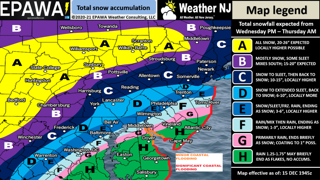
 Bobbob
 Think that means Ocean Low moved East bringing less moisture to the Western Low.
Still time to change again.
Go away snow. Some of us have to go to work and don't enjoy driving in the mess.
 JrzyGirl88
 Boom or Bust. Boom would be 12 inches plus. Bust would be 6 inches or lower.
I am going Bust. Very complicated storm.
I think in this case the areas that bust will be closer to the coast and farther south. I’m as confident as I’ve ever been when I say 12-18. There will be areas that get more but i don’t think we’ll be able to pinpoint that until it starts unfolding.
Should we salt prior to this mess coming? We still have some ice from earlier this week.
 justwondering
 No point, calling for 2 inches per hour at some points with 35 mph winds, this is a hunker down and wait it out storm....or, if your me.....a ride around your neighborhood on a snowmobile type storm :->
I’ve seen this storm go from 8-10 to 18-24, back to 10-18. Anyone have the final, latest greatest forecast?
Affected Area
Portions of northern and northwest New Jersey and east central, northeast and southeast Pennsylvania
Description
...WINTER STORM WARNING REMAINS IN EFFECT FROM NOON TODAY TO 10 AM EST THURSDAY...
WHAT...Heavy snow expected. Total snow accumulations of 12 to 20 inches. Winds gusting as high as 35 mph.
WHERE...Portions of northern and northwest New Jersey and east central, northeast and southeast Pennsylvania.
WHEN...From noon today to 10 AM EST Thursday.
IMPACTS...Travel could be very difficult to impossible. The hazardous conditions could impact the evening commute tonight and the morning commute on Thursday. Heavy snow and gusty winds could result in power outages.
ADDITIONAL DETAILS...Snow will move in from southwest to northeast this afternoon and early evening. The snow could become heavy at times tonight before ending Thursday morning.
As of 4:26am, NWS/NOAA says 16 inches. 12 to 20 range. Wind gusts up to 35mph happening late night, early morning. Ending Thursday morning.
90% chance of more than 10 inches, 65% chance of more than 12, 10% chance of 17 inches or higher, 3% chance of more than 18.
Here: https://www.weather.gov/phi/winter

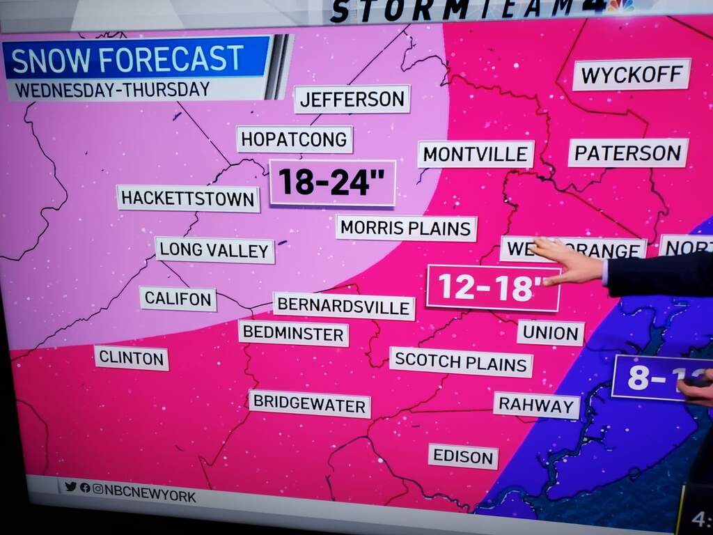
Yeah looks like 10-15 according to JeffReps map but right on the border of 15-20. So, I think Bryan’s 12-18 may still be the best call
from Washington Twp OEM:
Snow expected to start between 2pm-5pm, and be heaviest this evening. 10"-15" likely before ending at 10am Thursday. Highest wind gusts in the overnight.
 scarybigsnow
 6am NWS briefing: https://www.weather.gov/media/phi/current_briefing.pdf
12-18" forecasted. Next update 6pm at which point it will have begun.
LOL and now from Hackettstown PD:
12-20 inches...
So, somewhere between 10" and 20", apparently.... LOL
Forecast: sun, or clouds. Rain, maybe not. Snow: a little, or alot. LOL
I'm not blowing in high winds. I'll wait for the winds to die down before firing up my blower. So what's a good recent romantic-drama series on Amazon prime? I tried looking but can't find anything good to watch.
The funny thing is if they said 1-2 inches of rain no one would bat an eyelash or even know the how much actually fell. And that's basically the same as 10-20 inches of snow LOL.
Don't have to shovel rain off hundreds of feet of driveway!
Rain also doesn't make life miserable for the next several weeks.
 Josh
Josh It’s the wind Bryan. Not even that cold until tomorrow night. But given our current environment, outages, emergencies, everything is more difficult this year.
Think we are all used to a little “at home” time.
Just remember what the mayor of New York says: “No snow day for you, kiddies!”
"Rain also doesn't make life miserable for the next several weeks"
Speak for yourself! My life is going to be gold the next couple of weeks!
"Rain also doesn't make life miserable for the next several weeks.”
It does if it ends up in your basement.
Except if your basement on top of a hill gets water in it; you’re gonna need a bigger boat.... :-)
You're trolling right consigliere? Start times weren't even until 2pm at the earliest.
 Iampc
Iampc 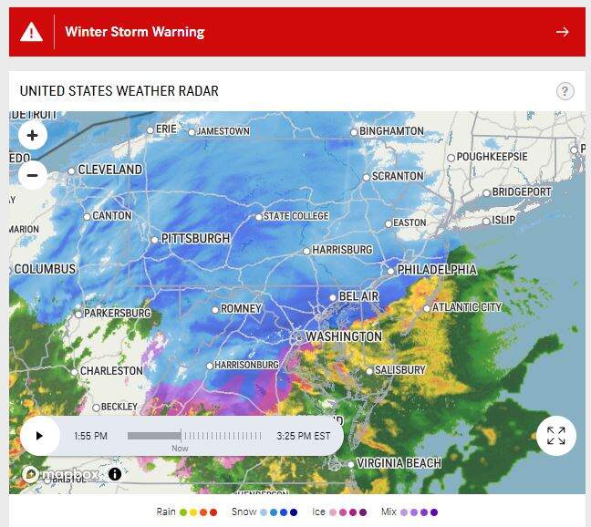
Total sarcastic troll-job based on previous posts from previous years. I made myself chuckle but I guess I’m the only one lol
 Not In NJ Anymore
  Philliesman
 Although I was joking with the “dud” comment, it’s 3:40 and, well, yeah. Not too much. I’m going to go out on a limb here and say we’ll only get 6-8”.
Hope I’m wrong because a massive snow storm would at least add a little excitement to an otherwise dull quarantine. Is everyone else sticking with the 10-15? 15-20? I feel like the last 5 or 6 storms were hyped beyond belief. Mega storm predictions equal great ratings.
I am staying with 12 or more we have enough cold air in place to prevent it changing to sleet which happens often with these coastal storms the heaviest snow will occur 11pm - 3pm ish we will be waking up to a lot of digging to do ...
Looking at the radar and the rate the storm is moving, I’m hoping for snow lower than predictions.
At this rate I’d be surprised to even get 8”. If this thing is yet another over hyped dud, I will have zero faith in these weather reports moving forward. Sure, a “potential” for 24” was there yesterday. But there was also “potential” for 6-8”. But that doesn’t get people to tune in to the news.
And yes, I’m still trolling but now only a 10% troll.
Nws/noaa just droped the 16 to 13. There’s a lot of storm still coming.
West of us, on the Eastern Divide, got dropped from 12 to 5.
Like I said in the beginning, a slight shift in the coastal low by even 50 miles will change things on this one. The coastal low provides the water.
"But there was also “potential” for 6-8”. But that doesn’t get people to tune in to the news."
That's what she said.
 callitlikeIseeit
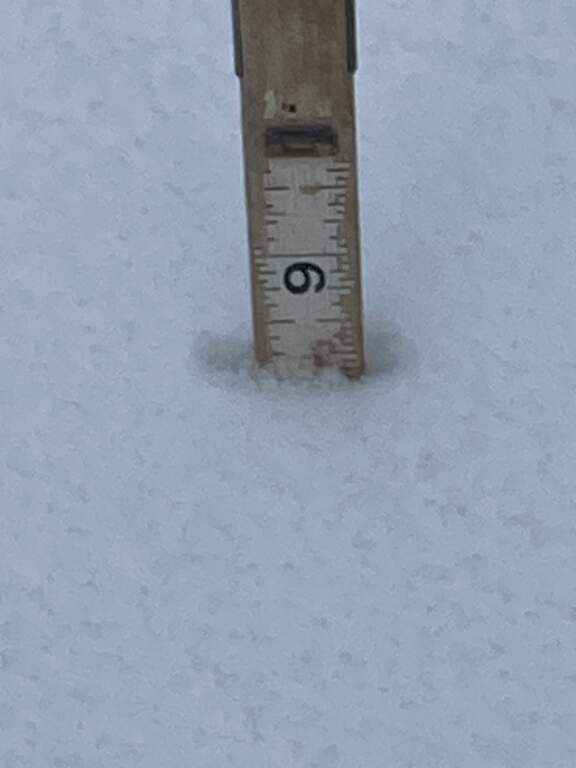
 I have 3 inches on the ground already... ugh.
Headed out shortly for my first round of shoveling.
in Rockaway right off Route 80 by the mall. Lighter snow with sleet mixed in. Just went for a walk. Some gusts of wind , not much. .......Just rechecked out the window. It has stopped snowing completely. Unless we get a real dumping overnight, this storm moved and bummer.
Looks like we are in a bit of a dry slot for now. My guess is it will fill in.
 ianimal
 4" in Indy at 11:50pm.
I'm so tired of the media hype machine. Saw one report a few hours ago with the words "Deadly Snowstorm!" plastered on the screen. Nope, just a 6" storm. Well, that's if it starts snowing again. Haven't seen one flake (that wasn't blowing off my roof) for hours.
Some say there will be much more over night but what I say is...........
DUD! xD
24" ??!!!???! hahahaahaa
Don't think it is a dud here... .the hail is crazy out here in HT. Got to give it to the weather guys!!!
 Mmadone
 Your telling me that the media overhyped this for ratings?? They don’t do those sort of things. lol
Weather forecasts are laughable at best. They can barely get the temperature right. Not even close with this "monster" and "deadly" nor easter! Just another giant meteorological forcast fail. Keep up the great work media!
 NoSnowForYou
  Bemused
 Has anyone ventured out on the roads yet?
I live in town and have to decide whether I’m driving to Pompton Plains for work today.
Haven’t shoveled my driveway yet and my street still needs more plowing.
 Dam
Dam 
About 7" down here, but that's deceptive because it sleeted for a couple of hours overnight (so my wife says :) ). It's annoying, though, because it sticks to the shovel.
 JJB
JJB Storm Team 4 says "Belvidere 10.4 inches" That was against the last forecast of 13 inches which was moving down from the previous 16. So, within 80% of the forecast which was a downward trend to begin with.
Like I said, a track difference of 50 miles on the coastal low would make a big difference in snowfall totals so a 20% change is probably guessing the track within miles. It also made it colder, so I guess they were wrong there too. Of course, a forecast, by definition, is a prediction or estimate so......who's wronger ---- the forecaster or those who expect absolute accuracy. Personally, I would rather err on the side of caution.
In this ----- thanks to JCPL who really jumped on any outages in our area generally getting them within 3 hours. We were still losing a few folks, just a few, as late as 6am this morning. Just a few is a blessing. On the coast, not so lucky.
Dam, good thing, if it was anything over 9 inches you would have needed a different measuring device :->
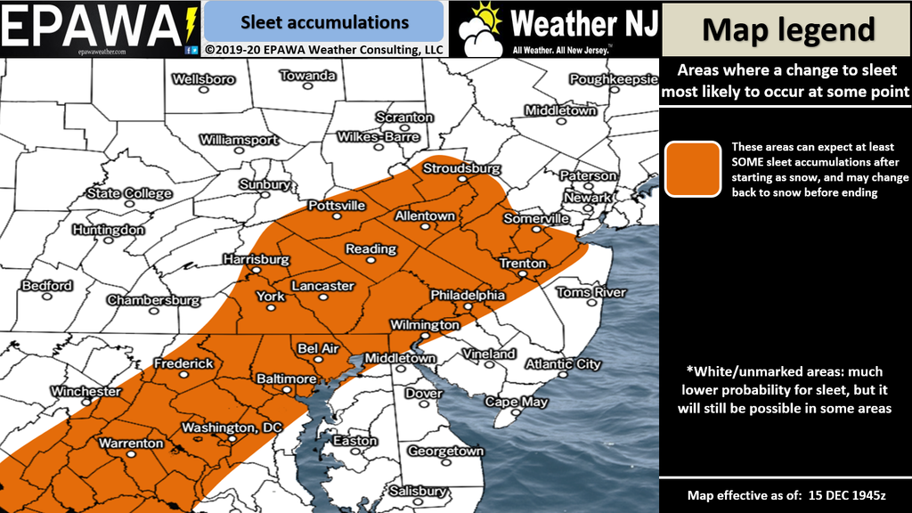
The sleet kept amounts down by a good 2-4 inches. Fair enough it was a bit of a bust on my 12-18 call. I looked over a bunch of official reports and there was a general 6-12 inches from Morris county up through Sussex.
What I like about the NWS/NOAA "probabilistic winter model" is that they update the experimental version quite often making changes as the storm moves. Last update was 7.30pm which held the 13 inch marker. Close enough for me. NAmerican model much better than in the past.
From Ogdensburg to Sussex, they got the 12-18, just depending on the banding, Byran was just off by a few miles :>)
If you saw the radar, it started out going right over the north of us up to Newton on the Sparta and beyond. At the same time to the south it went down around Flemington and up towards Plainfield. It left this protected pocket just to the west of us. Not surprising to see additional totals 4" or more just to the north of us.
3 hours of blowing and shoveling snow = storm was NOT "a bust" LOL
A "bust" would have been not having to fire up the snow blower at all.
After 30+ years raising our family in Independence, 2 weeks ago, we packed up and moved to Charleston, SC. We missed the big snow storm, but mostly we miss our good friends up north. Lots of great memories.
Not sure when I'll stop reading the comments on HL or watching the New York newscasts on TV.
Thank you all for keeping us updated on life in Hackettstown! Stay safe and well everyone.
 TU
TU I think 80% is good for govt work. And those looking for 18-24 or even 18; here’s a buck, buy a clue. The 4:26pm update, with % chance of all amounts from NWS/NOAA pretty much nailed it. Then the 7:30pm update lowered the forecast even more.
If you were looking for 18-24, think you missed the updates.
So yeh about a 100 miles away. The storm itself was not a bust but locally it was.
https://www.syracuse.com/weather/2020/12/binghamton-buried-under-more-than-3-feet-of-snow-a-new-record-see-photos.html
I’m with JR. If this was a bust, why did I just spend a couple extra hours snow blowing? And that’s a 52-inch blower on a small tractor..... it was working pretty hard. Very heavy.
Thank you Lord for the blue sky. Appreciated.
They were touting 18-24 in our area for days. The storm was supposed to begin at 10am, then 1pm. So, SD here’s a clue for you: The 4:26 pm update was hours after the storm was supposed to start. Great job “forecasting” 3 hours into the storm. I got a little under 6” in Indy. I looked at the radar myself around 11:30 and posted we’d get 6” (see above). Does that mean I’m 100% on my forecast? Lol this was a dud. They were high by 12-18” on the forecast 12 hours before the storm hit. The media lies to get ratings. Period.
Took me about 3 hours too with a few breaks . About halfway through I realized the gas in the snow thrower was almost 2 years old since I didn't use it once last year . Guess that fuel stabilizer works !
Afterwards I watched the first installment of Stephen King's The Stand on CBS All Access which released today . Not bad , but the 90's version started better with BOC's Don't Fear The Reaper , this one starts in the middle and flashbacks to the beginning . The rumored casting of Marilyn Manson as Trashcan Man was just that , as the part will be played by Ezra Miller and the part Manson was to play was dropped .
https://consequenceofsound.net/2020/11/marilyn-manson-role-cut-the-stand-miniseries/
http://themoviebox.net/15792
 97XBAM
 Their dopey snow totals map are showing 12-18 in our area. Makes it look good for television I guess
So what was the forecast for Binghamton in the days leading up to the storm?
I would much rather get 10" when I was preparing for 18-24" than to get walloped with 40" when they were calling for 6-8", which wouldn't have batted an eye Upstate.
LOL that they were deliberately lying "to get ratings", Consigliere... you really believe that they KNEW we were going to be in the 6-12" range?
When some NFL analytics guru like Cynthia Frelund runs her computer models and predicts that the Chiefs are going to beat the Raiders and the Raiders win the game... was she "lying"? Or are football games and the weather simply far too complex with way too many variables to be accurately predicted with computer models?
The reason why they were wrong is because the track shifted north and west. Bad forecasting, not sensationalism.
Scranton to Southern Vt got 30-40” when they were originally left out.
That area of New York state can get 200 inches of snow in the winter...they have the plows to deal with it...infact interstate 81 is already reopened
Consig: am I reading this right; you had 4 inches at midnight and ended up with 6 inches? Six inches would be bust for sure.
If you read my posts starting as of a few days ago, it sure sounds like NWS / NOAA was putting all the %%% in place. Certainly not for six inches though. That’s really low. I had 4 but that was a warm and windy area so much melt, much blow.
Love Byran’s opinion, but seems their prediction model is much better; rarely use the Euro model anymore.
Most official forecasts were for 12 - 18. Warren Co was about 80 - 90% of the low. . Over a week ago, we were told there would be a storm Weds afternoon - Thurs morning. They nailed that. It's weather, people Those who want their back yard inches nailed with in an inch do not understand weather. I think the forecasting was terrific on this because I understand that with weather *there are unknown variables* that cannot be known. The fact that a major snow storm was projected so far in advance - down to the timing - is impressive. We had some major ice around 11 pm. A dry slot moved in. Warm air moved a bit north. And yet we had the storm, timing as exactly as projected. Job as well done *as possible*.
Aside: stop following the amateurs who tout kabooms and meatballs on Facebook and focus on pros. Network TV are not pros, btw.
And God made the world in seven days.
HL: “hey, you blew it, you only needed six.”
Holy cow, Ianimal. Do you have a meteorologist family member? Lol Yes, they absolutely lied. There were potentials for 18-24. There were also potentials for 6-8. Not ONCE did I hear 6-8 as a possibility. Just “deadly nor’easter” and “snowmaggedon” that’s sensationalism at its worst. I’ll go out on a limb and say it was for ratings. But then, you probably believe everything the magical light box tells you....I mean, they’d never lie, right?
Snowball fight.. Everyone safe? Good. Plows cleared your space? Then all is well. Thankful we were not in the 19 car pile up in NY.....
Where I lived in Lake Erie is the heart of Welches Grapes. It’s about 5 miles wide on the lake and 60 mules long. The farmers forced the state hwy to be built beyond the flat, gently inclining fields on the ridge behind. Contrary to myth, the snow does not fall in Buffalo or on the lake but on and behind that first ridge. That’s the snow belt.
Two things happen. Often it would not be snowing when suddenly all these semis would suddenly appear off hwy and on the lake road. That meant it was snowing on the ridge and soon it would back up and start on the lake. The warmth of the water caused the effect. Second, that’s the section of hwy where the 100 car pileups occur often. I myself have been in a whiteout up there, drop down to the lake and not a flurry for 30 minutes or more.
Once in the belt outside of Buffalo, I went out a window on to a one story roof and walked off; the drift was that tall. To us, snowballing was an art form.
I like a good snow but am cautious with wind and blizzard conditions. Given the breeze, and the wetness of this snow, coming up short is OK by me. Higher winds and more wet stuff could have gotten dicey. And I still say NWS/NOAA did ok, just have to read it all vs. clinging to a sound byte.
Still don’t know how consig has 4in at midnight and only 6 the next day. Must live in a wind tunnel. Most of mine was around 10 except the higher drifts and lower wind effects.
SD said:
And God made the world in seven days.
HL: “hey, you blew it, you only needed six.”
Right??? LOL
good post 4of4. Like i said the storm overall was well predicted. Yes they missed the totals for your area by a few inches. Also i doubt the 'pros' were out there using the words 'deadly' noreaster and snowmeggedon (although it was a noreaster and yes it was deadly but i get the point).
It is true that it is not possible to predict the amount in everyone's backyard which is what i think some people expect. It's science, it's complicated and a true meteorologist would tell you it's never going to be perfect. I actually like that percentage system they use. That's the most realistic and the really should start using that instead.
Too complicated for the average American :>)
Bryan, do you think American model has gotten better? Do you use the European model than much anymore?
It is not easy forecasting snow. 10" of Snow is roughly 1" of water equivalent. If we didn't get all of the sleet we would have had a few more inches or more. What happens in the Summer where 1" of rain is predicted and we get 3". Not a big deal unless you live near a stream. If it were snow we are talking 1' versus 3'. The weather is the sum of all activity on the planet plus solar activity.
I live just south of Harrisburg Pa. We got about 14 inches. They predicted 18-24. The only problem was trees coming down. Our power company is Met-ed, which is owned by First energy. If you call in an outage, you get a JCP+L operator in NJ. A tree came down and took out the wires on my road at 6:10 pm. I called it in at 6:15 and was told my power would be restored by 8:00 am the following morning. Their estimate was pretty close, I got power back at 9:30 am on Thursday. Fifteen hours with no heat and it was 19 degrees all night. About par for the course for JCP+L.
 mac
mac Ijay...not that simple..the warmer it gets..the heavier the snow..fewer inches...they need to stop hyping these things because soon no one will listen
strangerdanger - i'll be honest i'm not an expert on the models by any means however overall I know the GFS has improved over the last year (it did well with the tropics this summer) while the Euro has gone downhill a bit (it did not do too well over the summer). I think the Euro was better with this past storm but it did show the heavy snow over your area when it wound up being farther north.
It was mentioned earlier. It is very variable and they need to error on the higher side. There are microclimates everywhere but we don't see them with too much impact in NJ. Go to places like Jay Peak in Vermont which averages over 300" every year and has what they call orographic lift and then can get 10" of snow but a few miles away they got nothing. Only if our government invests more in IT for the NWS will it improve, but it will never be perfect.
Like ianimal said, I would much rather prepare for 18-24 inches and only get 6-8 than expect 6-8 and get 40.
The idea that upstate NY is used to getting lots of snow is preposterous. I went to school in Binghamton and while the highways may get done quickly, the city streets are quite another story. The fact that they've got snow the height of a 5 year old in less than 24 hours is going to hamper any city's preparedness.
I still had to shovel and it looks like the snow is going to stick around due to cold temperatures this week, so enjoy your White Christmas while you can.
Bryan, thanks. According to wiki, we had fallen behind, and added some horsepower in 2019: "In 2019, as a result of the recent tenfold increase in computing power, an upgrade to the GFS model is planned that will increase its horizontal resolution to 9 km and 128 layers out to 16 days, compared to the current run of 13 km and 64 layers out to 10 days."
The instigating feature to add previously withheld funding was: "This was most notable in the GFS model incorrectly predicting Hurricane Sandy turning out to sea until four days before landfall" Now that was a miss. And a miss that NWS/NOAA predicted due to funding shortages. I still remember looking at the tracks and saying: "this sucker's turning inland....it's coming inland...."
Used to rely more on Euro, but have been getting by with the GFS lately. And yes, been using the "probabilistic model" now for years; it keeps adding features and getting better. I like the % ratings for the different snowfall amounts since it opens the range of possibility as well as providing trending.
I do feel weather is trickier to predict than it was a decade ago. Seems the variability and intensity has increased pretty dramatically. Living on Lake Erie, I am used to it. There's no model that can predict what happens there. Too unpredictable. We used to say: don't like the weather, wait an hour.....
SD, you’re more than welcome to come visit my wind tunnel and bring a yardstick. Though, half of a ruler is all you’ll need. Nothing has melted since the storm so I’m still surrounded by 6” (or less) of snow. Better luck next time...
Thanks consig, but no compression? Wow. I’ll take you at your word that you had 4 inches round midnight and only 2 more inches over the next nine hours of the heaviest bands.
The weather channel also called it a bust. Of course, they were talking Binghamton, no bust called for our area.
And storm center called it 10.4 in Belvidere so obviously different amounts fell within miles.
Not a prob, six inches you called it, in which case.a warranted bust. My house, within miles of you, looked more like Belvidere, but I got zero sleet and with the wind, really hard to call an average.
Hagn.
I believe the "weather predictors" do the best they can do. Weather is ever changing; a bit of wind here or the bit of wind that was supposed to be here decided to move in an unpredicted direction but Just Enough to change things in my neck of the woods. In ny area of Indy we had a little over 10". That being said, our family in Binghamton got 42" at one house and 44" a short distance away. Either way, 42" or 44" this was a Monster Snowstorm! That area of NY is used to getting big snows, but this one was among the biggest in memory. One snowfall jackpot as of sunrise Thursday was near the National Weather Service office in Binghamton, N.Y., where a staggering 40 inches fell. It observed an astonishing 20.5 inches in six hours. The city obliterated its record for the heaviest two-calendar-day snowstorm.
 Mrs. Pipes
 Binghamton avg snowfall = 64in.
Buffalo ny, Erie pa, 90-100in.
And the big ones are just outside those two cities.
Ao this one snowfall; 5 inches an hour, is 2/3rds their year in 24 hours. Big enough to collapse buildings.
I have been in bigger ones. But I was so much shorter then, I’m taller than that now.
Possible storm on its way Jan 25th and 26th ... let’s keep an eye on this one ... I love snow so I am crossing my fingers ... any other weather geeks looking at advanced models?
According to accuweather it looks like 1.2" during the day and another 0.7" at night. So, as of now, 1.9"
Not me. I work for a living- so have to shovel and drive in it.
And my hobbies are warm weather based- even if just playing frisbee with my dog.
C'mon spring!!
 Greg
Greg  Botheredbyuu2
 Yes, but the last week of January into the first 2 weeks of February is the historically snowiest period of the year.
 Snowman
 Winter weather advisory from 7:00 am Tues thru 4:00 am Wed. Snow, sleet and freezing rain. Snow 1-3” and ice 0.1” to 0.2”
 Local Gal
 I don't have bread or milk :(
Beer and wine are plenty :)
For the 3 of you that have to drive, be careful!
What’s up with Sunday/Monday? It’s been showing a few inches both days for awhile. That often is an indication of something potentially bigger, but I am not reading anything about it. Anyone else?
It's official, Calico called it right!
Little snow,
little ice,
might not plow...
that's mighty nice.
Started late,
ended early,
makes me smile,
I'm less surly.
Burma Shave.
 Nan Davis
 It’s quite icy from the freezing rain and drizzle right now. Drive carefully tomorrow morning!
First 2 weeks of February is our snowiest period. I hope it is a dud but statistically it won't be.
Things still need to come together but there is decent snowstorm potential for Sunday night/Monday. You better hope because after that the pattern looks like a bunch of lake cutters which basically means no snow for you.
We need to keep an eye on the storm coming Monday and Tuesday... looking to get at least 6 inches and it’s to far to say any more then that
As of today 4 - 8 inches coming Monday into Tuesday most snow to fall on Monday during the day.. more details to come
This one is still too far out, think this is first take by NWS and probably won't commit until Sunday :>)
Right now NWS snow report says 3 in, more South, 0% chance of over 6, 2% chance of over 4 in. Winds should be on the coast but we will have some wind; that's always one to watch in these nor'easters.
Way to early yet and much can change based on final track.
According to accuweather it looks like 6-10” from Sunday night through early Tuesday morning.
depends on how close to the coast the storm is. tracks east less snow. tracks west more snow. they don't know the track until Sunday
...WINTER STORM WATCH IN EFFECT FROM SUNDAY EVENING THROUGH LATE MONDAY NIGHT... * WHAT...Heavy snow possible. Total snow accumulations of 6 to 9 inches possible. * WHERE...Portions of northern, northwest and southern New Jersey and east central and southeast Pennsylvania. * WHEN...From Sunday evening through late Monday night. * IMPACTS...Travel could be very difficult to impossible. The hazardous conditions could impact the morning or evening commute. * ADDITIONAL DETAILS...Snow will develop west to east Sunday morning and last through late Monday or early Tuesday. The highest snow totals and snowfall rates are most likely to occur late Monday.
They pretty much know the track now, but models are still coming up north a bit. Then there always is the dry slot lol. Stay tuned.....
 Patti
Patti They "think" they know the track now. Still early. Last 3am NWS model says 8 in but 9-11 at Eastern edge of the county so certainly the track moved North or West a bit. Range is 6-9 inches with a 50% chance of more than 8 inches, 80% chance of more than 4 inches Snow band also got a bit wider, winds picked up, but the big gusts are still on the coast. Timing is Sunday evening start through Monday night with most of the snow arriving Monday pm.
In a day the track moved from 3 to 8 inches, it can move again, worse case seems to be about a foot if you're in the "sweet spot" of the track.
Should get an update this morning. This could be a nice snow with moderate temperatures, not many gusty winds, and a long duration. Hope it's fluffy.
I for one am so tired of the way the TV stations constantly promote "the big one" each and every time it may snow. They get everyone all amped up and then we end up with an inch or two of snow. I have stopped listening to/watching the weather forecasts in winter. So ridiculous!
 Pamela
 The truth is there will be sharp cut-offs in terms of how much snow and that makes it really difficult to pinpoint. We know the storm is coming. But the range of outcomes right now is probably anything from just a few inches right on up to a foot and that can happen over a distance of 50 miles. The closer it gets the more you can hone in on that but inevidably we may not know for sure until we start seeing it on radar.
 EVV
EVV My vaccine appointment is Monday at 4:45 pm. I will be there. They said they will plow the parking lots. Rockaway Mall. Fingers crossed.
4:45 probably good. Even if it starts, they saying the accumulation will be monday.
I think most are used to the ranges given the unpredictability of the storm track. Bryan’s ranges match the NWS ones I posted above.
No update yet today so track must not be radically changing. But still early yet and we may not know till late Sunday or later.
You should be fine, Coach. If they have the timing correct, they will have plowed sections of the mall at least once or twice by the time you get there. You’ll maybe see an inch on the ground which, unless your tires are bald, won’t be a problem. Good luck to you.
NWS just issued a Winter Storm Warning calling for 11-15 inches from Sunday night through Tuesday morning.
 Forcefed4door
 EPAWA has us 12"-18" (it's not loading right now, but I saw the map a few minutes ago)
...WINTER STORM WARNING IN EFFECT FROM 5 PM SUNDAY TO 1 PM ESTTUESDAY...
* WHAT...Heavy snow expected. Total snow accumulations of 11 to 15 inches. Winds gusting as high as 35 mph.
* WHERE...Portions of central, northern and northwest New Jersey and east central and southeast Pennsylvania.
* WHEN...From 5 PM Sunday to 1 PM EST Tuesday.
* IMPACTS...Travel could be very difficult to impossible. The hazardous conditions could impact the morning or evening commute. PRECAUTIONARY/PREPAREDNESS ACTIONS...
As of 5:30pm, NWS back at 11 inches with the 11-15in forecast covering the region. Morristown estimate for 14in, New Brunswick 15, and Allentown 12 so heaviest is East and South of us. Hopefully the 35mph gusts will be too; anything less would be nice. Coast getting 40-45mph gusts.
Start time is 10pm Sunday so don't yell dud till the morning hours as it ramps up on Monday. Coach, I got my days messed up, will cross my fingers, leave early and it's just snow and some wind --- should be no ice and I am pretty sure the plows will keep up with it. Should be able to see the bands on radar. Temps not that bad. From here to Rockway seen as "minor impacts" to life. Just don't go South :>) Blowing snow seen as "limited impacts."
Right now 75% chance of greater than 8 inches but only 40% chance greater than a foot. This thing is by no means locked in; the next update should be by early tomorrow morning although the probabilistic model can update at any time. I still expect more movement, more likely reduction than increase. But with such a long duration, who knows.
https://www.weather.gov/media/phi/current_briefing.pdf
Basically a foot of snow predicted. On the positive side no ice accumulation predicted.
Some short term Models are showing 10-20” where the banding sets up. Of course not sure exactly where that is yet.
...WINTER STORM WARNING REMAINS IN EFFECT FROM 5 PM THIS AFTERNOON TO 1 PM EST TUESDAY... * WHAT...Heavy snow expected. Total snow accumulations of 15 to 19 inches. * WHERE...Portions of northern New Jersey and east central and northeast Pennsylvania. * WHEN...From 5 PM this afternoon to 1 PM EST Tuesday. * IMPACTS...Travel could be very difficult to impossible. The hazardous conditions could impact the morning or evening commute. * ADDITIONAL DETAILS...Snow develops late this afternoon and will last through Monday night or early Tuesday. Snow may be heavy at times on Monday.
Even if a dud at 30in, it's a lot of snow still. A prolonged event with some wind. Latest 6:30am NWS track says we get 17in. There will be some winds, 35-45mph gusts and travel will be difficult.
Let's hope we get a little shift to the South and East, it's a long duration event. Start time is 7-8pm tonight, severity has moved to major.
While the probabilistic model will update earlier, the next major update is 6pm.
That's a long ways off the original 3-8 inches even with all it's caveats and probabilities.
https://www.weather.gov/media/phi/current_briefing.pdf
We should get at least 12-18" across the area with some areas approaching 24".
Welcome back Winter...
BTW, my bird feeder currently has more birds for the Winter so far, do they know something?
WINTER STORM WARNING REMAINS IN EFFECT FROM 5 PM THISAFTERNOON TO 1 PM EST TUESDAY...
* WHAT...Heavy snow expected. Total snow accumulations of 18 to 22 inches.
* WHERE...Portions of northern New Jersey and east central and northeast Pennsylvania.
* WHEN...From 5 PM this afternoon to 1 PM EST Tuesday.
* IMPACTS...Travel could be very difficult to impossible. The hazardous conditions could impact the morning or evening commute.

NWS probabilistic model has us at 19in as of 11:30am. Morristown, Mt Pocono, Allentown at around 22in. 10% chance of over 21in or under 9in. 92% chance over 8in but 72% chance over 12in so there's a bit of wiggle room in the model.
They are not issuing gust potential for us, but if they do ---- probably up to 35mph.
It started dusting about 1PM in Hackettstown, just in time for me to get my new car battery in and go pay my storage fee. Traffic is about as bad as afternoon rush hour usually is!
 Phil D.
 We've got about an inch and a half at 3:30. Good thing it's not going to start until 7 or 8, lol.
I am crossing my fingers and hoping this storm over performs and we get 2 feet or more ...
So glad I'm living in Tom's River now. 1-3"
You guys maybe 2 feet?? I feel for you.
Eh, I wouldn’t mind if we got 60”. Everyone at chateau consigliere is working/schooling from home plus I have a beast of a snowblower so I wouldn’t mind playing with it multiple times. I do feel for those that have to drive in it tomorrow morning. Stay safe everyone.
"I'll take 3 feet if it is the last plowable snowstorm of the Winter "
" I do feel for those that have to drive in it tomorrow morning"
Can't drive if I have to shovel for hours...no plow here.
If applicable - Just a reminder to clean snow from around your standby generator in case of power outage and generator kicks on.
This place is already looking at a giant storm for next weekend. I'll save you a lot of reading of their post: https://www.weatherboy.com/european-forecast-model-suggests-major-superbowl-snowstorm/
with this final paragraph:
For now, this European run is an outlier: it does not align to its own run from last night nor does it align to the American GFS forecast model output, which suggests a completely different storm-less outlook. Nevertheless, it is worthy of keeping an eye on –especially because it was able to lock in on the storm impacting the Mid Atlantic now fairly early and relatively accurately.
It's a one-run outlier, and they've made a news story out of it.
...
However, I do see 4 consecutive days of precipitation next weekend, and that raises a red flag. See my post from 5 days ago about this storm.
Win-win for them: a feather in their cap of calling it early, or creating a frenzy on their Facebook group/driving up ad revenue on their (really bad) website.
Let's watch and see...
Just stay safe. Whether you wanted the snow or not (hellllllo JrzyGirl88 and Mrs. Pipes - LOL) Just don't drive or shovel too much if you can't and know your limits. Enjoy it from inside, IF you can. Hoping everyone stays as warm and cozy as they can. Seems like we're in it for a long haul. On nights like this, I like to think of myself as 10 again and waiting for 'And XYZ is closed today' school announcement on the radio back then, LOL
I know this will not be a popular post, but I am SOOO loving this! I love winter, and I love snow. I'm heading out shortly to ski around my neighborhood, and hoping to snowshoe up the 800 ft hill behind my home. A friend in the Catskills has a barn full of snowmobiles, so we'll be doing that all weekend.
I sympathize with all the folks who dislike cold weather and snow, but I have to wonder why you choose to live in the northeast? I realize family and jobs are very strong influencers, but you only live once. If I lived in Florida, I'd be miserable, and would definitely not stay.
Anyway, please stay safe, don't drive if you don't have to, and for those of you who hate the white stuff, just keep telling yourself that the first day of spring is only 7 short weeks away! :-)
 Rob Durana
 Born and raised here and mom is here, so staying put for now. Heading south eventually. But not Florida. Lol. I don't mind the cold but the snow is annoying.
Have fun today. Stay safe.
We are talking about 24" in many areas and at least 20".
Next weekend is a bit far away but looking like 6" per the models.
Indy: at least 12" in my neck of Indy. It did not stop here at all and is snowing quite heavily. Driveway is very steep, and I have no idea when hub and I will be able to clear and get out of the driveway. Ridge Rd. is thick with the white stuff. I like the snow, but at our ages this much snow is a real problem for us. But we're staying in NJ because we would hate living in hot and high humidity States. We've visited those States and know we would rather have the Snow.
I agree with Mrs. Pipes. I'm in Independence, I'm in my 70's, and I just fell in my backyard while clearing a path to my birdfeeders. It was very difficult getting back on my feet. I grew up here & have no desire to move anywhere. Roots are too deep. But I realize it's winter in NJ, so snow is expected. We've actually been fairly lucky the past few years when it comes to snow, although the power outages from a slight breeze are annoying.
 The Rhyme Animal
 It's blowing so bad, there's no way for me to get an accurate measurement. But I just got a Nixle that said everybody (in our area) is now going to get 20"+
What are the guidelines on cocktailing while attacking the white stuff for the third round? Asking for a friend. When I say friend, I'm referring to one of the voices in my head.... LOL.
If cocktailing means drinking- I've been drinking while shoveling for hours now...and I am loosing the battle against the snow.
Anyone who thinks this is fun can 'sit on it' as they said on Happy Days.
I had to cancel work today- so no pay, shovel and hurt, not even remotely close to done...and anything I've done just keeps filling in...and I'll have to cancel work tomorrow and loose any income then as well. Not to mention the rest of the week actually trying to work is a nightmare from people who have SUV and just drive over their unshoveled driveway, pull into their garage and don't touch their walkways.
Anyone that wants to come help shovel- I have numerous high ABV IPA and other beer, as well as good wine, Tito's, etc. :)
I am already planning my snowmobiling trips for the week, probably will just take the whole week off at this point, get it while the going is good!
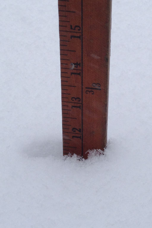
PV at 4 have 16 inches on deck. Did the driveway with the snow blower at 1
 exphysics teacher
 Looks like it's decided to hang around awhile longer.....
URGENT - WINTER WEATHER MESSAGE
National Weather Service Mount Holly NJ
401 PM EST Mon Feb 1 2021
...SIGNIFICANT WINTER STORM CONTINUES ACROSS THE REGION...
NJZ001-007-008-PAZ054-055-061-062-021015-
/O.EXT.KPHI.WS.W.0001.000000T0000Z-210202T2100Z/
Sussex-Warren-Morris-Carbon-Monroe-Lehigh-Northampton-
Including the cities of Newton, Washington, Morristown,
Jim Thorpe, Stroudsburg, Allentown, Bethlehem, and Easton
401 PM EST Mon Feb 1 2021
...WINTER STORM WARNING NOW IN EFFECT UNTIL 4 PM EST TUESDAY...
* WHAT...Heavy snow. Additional snow accumulations of 7 to 10
inches. Winds gusting as high as 35 mph.
* WHERE...Portions of northern New Jersey and east central and
northeast Pennsylvania.
* WHEN...Until 4 PM EST Tuesday.
* IMPACTS...Travel could be very difficult. Areas of blowing
snow could significantly reduce visibility. The hazardous
conditions could impact the morning or evening commute.
* ADDITIONAL DETAILS...The heaviest snow will end by late this
evening. Periods of light snow accumulating snow will linger
through Tuesday.
PRECAUTIONARY/PREPAREDNESS ACTIONS...
If you must travel, keep an extra flashlight, food, and water in
your vehicle in case of an emergency.
The latest road conditions for the state you are calling from can
be obtained by calling 5 1 1.
 GR
GR Hopefully will start breaking up by midnight depending on how long the western edge lingers. You can see it breaking up on radar now. Snow squalls will linger till tomorrow afternoon.
Why do they build generators that require snow removal? Guess that’s next years project; 3 foot ductwork on either end connected with bungee cord ! Cuz it ain’t the shoveling, it’s the snow walk that’s killing me.
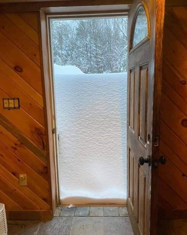
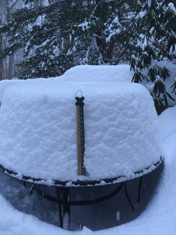
On the table on my deck, it was 22 inches as of 5 PM, in the Kenwood section. I wouldn't be surprised if the total so far were actually higher with all the wind since some inevitably has blown off.
 Rich
Rich  4catmom
  Embryodad
 It just won’t break up. Now looks like 9!pr 10am. I have a drift above my window!
 TJS
TJS 
Washington Twp OEM, 9:01AM tues
Although the bulk of the snowfall has passed, we are expecting another 2"-4" of local accumulation before the storm finally ends TOMORROW (wed) MORNING"
Going out to blow multiple times get old, but really the major trouble is the bottom of the driveway. As of now, the pile is 3 feet high and 3 feet deep. Going to have to dig that out "manually", especially if it's heavy or frozen to any degree. If it weren't for that, these huge storms really wouldn't be so bad.

I have drifts in my yard (downtown Hackettstown) that are well above my waist. Made a pass with my blower at around noon and again around 4:30 yesterday. Trying to wait until the last possible minute to go again today, as I am low on gasoline. Gonna concentrate on the driveway skirt and get a car out to go fill my gas can.
 Monty Smith
 4catmom right now it is looking like 1-3 inches from early Saturday through Sunday.
It is too far out to really know.
A bit over 30" in my Indy paradise. Between today and tomorrow the hub will get the driveway drivable. Driveway is long and steep. Best of good wishes to all who have heavy duty clearing ahead of them in this Winter Wonderland!
Nice to look at, not for anything else. I wish that kids came around with shovels. LOL. I miss that. I'd be waving money at them. ;)
Another one Sunday - Monday need to keep an eye on ... some models are showing significant snow 6 or more and if it tracks perfect it could be really big by Friday we should know more

Ch 7 5 pm news says 24.8 for Hackettstown. I'm in Liberty - seems low. We've got to be around 30"
 hammer
 Is that anything official, hammer? I wouldn't doubt it, but I'm curious if there is any news or weather source acknowledging that.
Parts of Warren likely hit 30"+. Newton had unofficially 35". This was probably the greatest single snow event in our recorded history. Definitely not for an entire season as we had a bad one in the early 90s.
That was miserable 2 solid days of shoveling. Finished at midnight last night.
I am soo sore.
We got up to High Point yesterday on the snowmobiles, other then snowmobiling in the mountains of Yellowstone, this was the best snowmobiling of my life.
We were the first ones on the trails and there was a minimum of 3 foot of untouched snow and some massive snow drifts that made for absolutely surreal riding, sure put the 1000cc to work! I couldn't be happier, and it made all the plowing and shoveling worth it!
Early on there was 1 cross country skier on the trail that was all thanks for us packing down some snow for him!
It’s up there but don’t think it’s record breaking. Winds have been worse too. Not a blizzard I think. What may separate this one is the duration; somewhere around 48 hours with a small after squall this morning. Even with my Buffalo standards, this was a good one, a little more wind, coulda been much worse.
I have a cornice on my roof ;-)
Wait, you rode from this area to high point? I never would have thought that was possible. Now I want a snowmobile lol
No, we trailered them up to the parking lot of High Point...but that would be awesome!
I always hope that some of the folks who have equipment that can help others will do so and offer help if they have available time, and ways to get to people who need help with snow clearing, food, medicine, (those kind of things.) In this area I think there are a lot of good people out there who could and would help those who are in need.
Ohhhhh, gotcha Darrin. Are you “allowed” to ride up there? Like, is the state ok with it? That sounds like an absolute blast.
@Consigliere, yes, the only motorized vehicles they allow during the winter are snowmobiles and they have to registered and insured, park rangers do patrol the parking lots and ask to see paperwork. They shut down some of the roads and leave them uncleared for snowmobile use. There is no trail grooming or anything like there is in places where you have to pay to ride, but this is free, so you have to get it while the going is good
@Mrs. Pipes, helped 4 other people fully dig out, and as the saying goes, no good deed goes unpunished, got my fingers caught in the snow blower (like a idiot) helping my friend clear his parents house last night....everything still attached, no hospital, but it feels like (and looks like) I smashed my finger with a hammer 4 times in a row
Ouch Darrin, that sucks man! Thank God everything is still attached! Could have been much worse!
I heard a little bit of snow overnight and early tomorrow, but it will change to rain before noon and the temp will get into the mid 40s. You might want to clear storm drains on your block if they've been plowed shut.
 Drew
Drew Darrin, I am so sorry you got hurt being a good guy! I hope your hand heals very very quickly! I'm sure the people you helped were thankful. Like I said, there are a lot of good people living in our neck of the woods, and you are one of the Good Guys!! Although I wasn't one of the lucky people you helped, "I am Thankful for what you did."
Say it ain’t snow! Just when many forecasters were brushing off the idea that another coastal storm would form this weekend and bring another batch of accumulating snow to New Jersey and other eastern states on Super Bowl Sunday, some are changing...
https://www.nj.com/weather/2021/02/nj-weather-another-winter-storm-with-snow-is-possible-this-weekend-forecasters-say.html
AccuWeather forecaster Bernie Rayno says there’s a 50-50 chance that a low pressure system off the Carolina coast could move far out to sea and not impact our region — or the system could move up along the Atlantic coast and bring accumulating snow to New Jersey and other parts of the Mid-Atlantic and Northeast region.
Anyone had roof issues yet? None here, but I'm concerned about the added weight if we get significant rain soaking into the 28" of snow up there...
Anyone here updates on Sunday's storm? The short range model posted by Edge Weather is downright depressing.... https://theedgeweather.blogspot.com/
 bonv25
 NWS has Warren at 4 and Morris at 6.
Of course, that’s how it started last time....
Time and track will tell but we are only a day out now.
Yes more coming Thursday let’s get past Sunday and see what the models says for the next storm.
 Courtney1
Hey Darrin, I’m running out of places to put the snow. You like it so much, can I bring you some of mine ;-)
In Buffalo, when it got high, they would load it in dump trucks and dump them an unused parking lot. Imagine the Shoprite lot full of dump truck sized piles all neatly piled starting at the back and extending out, one load at a time. Us kids could build entire snow cities in this lumpy snowscape.
We had backhoes in our neighborhood in Liberty yesterday. The snow banks were 8' into the street on either side. They came in yesterday to clear the streets - dumping on to our lawns. Fine with me. If we get more storms, we would be in trouble with the streets so narrow.
I hadn't seen this since the 17 storms in '94.
The snow quantity and frequency is what it is. This is the Northeast.
My concern is with safety. The height of the piles at intersections is a challenge. It really makes for dangerous situations. Here in town the DPW did a top notch job as usual. I see the high piles all over the area. Perhaps in the coming weeks towns et al will be able to address this.
EPAWA's Headline:
"No rest for the weary: next few weeks could be busy with storm after storm."
This one likely will be as it is supposed to be rain in Central Jersey...
Question now is, how many more weeks of this stuff?
 Soup Nazi
 I have always thought about the amount of snow melt when we have huge amounts on the ground, like now, and my fears never come true. It usually melts slowly enough to be absorbed over time.
Of course, if we had a warm up and a few inches of rain right now, then we would have a big issue(including possible roof collapses), but that is not in our future with the upcoming temps staying below 32 for most of the next week if not longer.
As they say, "this too shall pass" and spring will follow, regardless of our discomfort of present.
 Michael
 Many upcoming potential snow events in the next 7 days. What a February it's been for us snow lovers.
 Lenny Rock
 How many of you "snow lovers" are also actually the "snow MOVERS/shovelers"?
@ianimal, I went out with the roof snow shovel during the big storm. The back of my barn had a 6 foot snow drift on it!
If rain comes in the forecast, I will probably go back out and at least remove it from my vaulted ceilings. Supported areas I usually leave as I cannot reach them anyways
Any word on the rest of this week? Weather.com says nothing besides some very light precipitation until a potential storm on Sunday, but auccuweather says we are getting a storm Wed night through Fri with 12” possible??? These are wildly different predictions...
 Kat
Kat 
Looks like we're getting lucky... this one is skirting JUST north of us... Sussex County is getting it tho.
What’s the deal with the Thurs/Fri storm? Seems like NJ.com says it may bring a lot of snow to places in NJ but other sites like weather.com aren’t showing anything.
 D-ManPV
 Lol SD. False DUD!
Good question D-man. I have 2 weather apps on my phone. The weather.com app has NOTHING for Wed-fri but, like you mentioned, other sources I’m looking at say anything from 1-3 to 3-6.
Looks like we miss the Thursday/Friday snow but may get something small on Saturday/Sunday and then potentially a much larger snow on Tuesday.
Tonight's "event" = much ado about nothing. This weekends event looks to be far south of us as well.
Pic is for tonight/tomorrow
Hi all,
Where can someone rent a snowmobile in the area?
First time. Looking for a recommendations of place preferably next to the trail system.
Thanks
 Cos
Cos Next week, Tues Feb 16: weather.com is showing 5-9" for Weds. Dark Sky says 8 - 11". I've read there might be another system on the 18th, and those two systems could merge. If anyone reads anything, please post. Thank you.
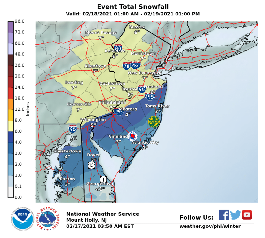
I know we’re still 4 days out but the weather underground app has 6” for Thursday.
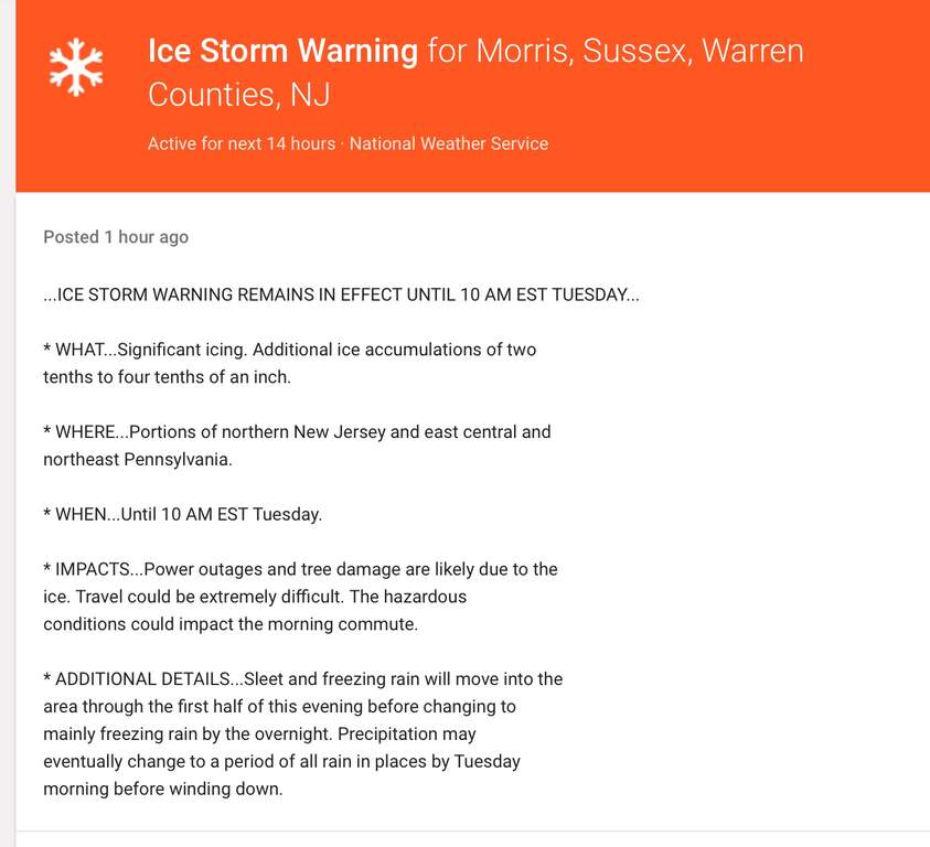
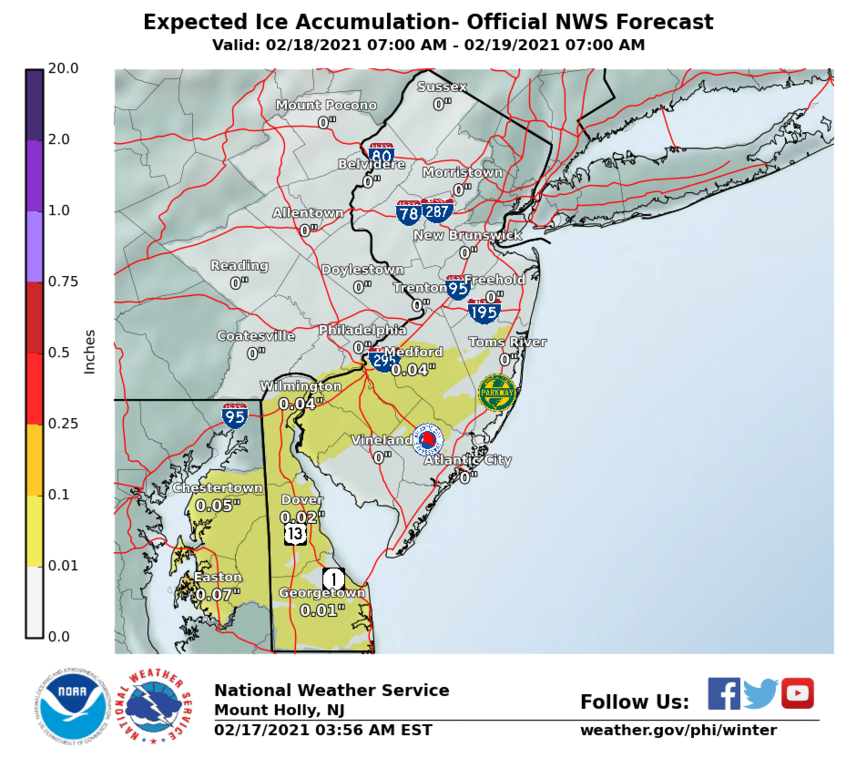
Tonight’s ice could be bad. Anyone fortunate to have a generator should test theirs early today.
As of 6:40am, we’re at .2 for ice. .25 is when things start falling so we’re in the neighborhood but not over. Healthy stuff shouldn’t fall.
It’s .3 above 80 so it’s still close and we have a couple of updates coming. Also it warms quickly but last time one of these rolled through, it lasted much longer and it never warmed up to meet the estimate. This thing is dropping ice from the gulf coast to maine so keep apprised of updates. They are certainly to change.
Higher elevations 800 feet and above will get slick. Thankfully warmer weather tomorrow should melt it but not until the afternoon. Water on top of ice will be very slippery on untreated surfaces until then.
We’re at .25 for ice now with same caveats re above 80. It’s starting later, some short bursts earlier. Should be midnight in earnest and warming/slowing around 4am but I don’t trust either of those estimates. Last time it went 4-6 hours longer than predicted and it never warmed up. Hopefully they got this one down better
Yes we lost our power in Great Meadows approx. 11:30 PM. JCPL restore time 3:00 AM. We shall see.
NWS calling for 6 inches, but this is real early and probably not a serious forecast.
If my kids miss another in person school day for more $&%(# snow, look out for the evening news story "Busy attorney admitted to mental hospital because kids never leave the house". Today was a complete waste of a virtual day.
 Tracy
Tracy I got the HPD alert about a Winter Storm Watch about an hour and 1/2 ago. Starting 4AM Thursday until 1PM Friday with totals of 5-8 inches
As of 4am, trending down a bit, an inch, to 6 inches. Still time for a few more guesses. So far, ice is south of us, but be prepared.
6-8"
https://www.weather.gov/media/phi/current_briefing.pdf
Updated briefing at 5pm today should be more accurate.
Or maybe a foot
The seemingly unending string of winter storms is expected to slam New Jersey with heavy, wet snow and the potential for dangerous ice starting early Thursday with the National Weather Service predicting 6 to 8 inches for the northern half of the ...
https://www.nj.com/weather/2021/02/nj-weather-winter-storm-to-slam-state-with-heavy-wet-snow-up-to-12-inches-in-latest-accuweather-forecast.html
That's the 3:20am view, at 3:50am, the experimental model showed the 6 inches and ice farther south. There will be a number of updates but your briefing indicated that the lower numbers due to cold as in ----- the colder it is, the less we get as the cold pushes it South, a familiar pattern. Temp wise looks to be in our favor on this one, but of course, still early to tell.
3:26pm NWS experimental model says 7 in and icing south of us. It’s a fairly long event so changes could keep coming late Thursday too. A nuisance but should not be crippling. Will be cold until Sunday. Enough with the grey and cold already. Bring on 32 and blue skies.
Good! Need some fresh riding snow on top of this hard pack! This is perfect!
Be safe everyone!
JrzyGirl88, I'm on your page!! Please, please - Go Away Snow!! If it comes, stay safe everyone!!
JrzyGirl88 - LOL. Your method hasn't worked this year of asking snow to go away. I think you might have to bribe Mother Nature. $$ Enjoy it! ;)
I will still ask every time. Commuting in it is horrible and I don't have the option to work remotely..
Stay safe and drive carefully JrzyGirl88!
I love winter and tons of snow, but I'm fortunate to be able to work from home whenever I want. I guess it also helps that I enjoy skiing (both downhill and x-country), showshoeing, and snowmobiling. It's been a great year for these activities, best in many years.
Shoveling my driveway is not my favorite chore, but I don't mind it either. It's a good workout! Who needs a gym? :-)
If you need to venture out today, please be careful. If you don't, enjoy the pretty snowflakes from the comfort of your home. And just know that in a few short months, you'll be wiping that sweat off your brow and your Air Conditioning will be cranking!
Thank you @ Rob Durana!
1 1/2 hours to get home on Route 80 from Paterson... Glad I went in super early and was able to leave. Hope others are able to do the same.
So, we've got a break...
NOAA says we're getting sleet next? What are all your various weather sources saying? I don't want to go out and blow if we have sleet/ice coming; I'd rather have that on top of the snow, and I'll remove it all (tomorrow if necessary). What I DON'T want is to remove it, then have freezing rain turn the now-bare surfaces into an skating rink...
Ice on top of snow is always better than the opposite!
We are doing the exact same thing JR, waiting until it is over. Weather at noon said there will be periods of a break in precipitation but will continue until tomorrow.
Yes a break, yes more coming --- till tomorrow pm, not more than an inch, some sleet possible ---- was pelletized a moment ago. About 50% chance at any time. Will go above freezing by Fri pm, eh ---- I'm removing what's there and will figure out the rest when it happens..... Got to get out tomorrow and rather not drive over it and can handle a little ice. Figure if it does ice that it will be gone by pm Fri.
Jefferson Repub .. thanks for the info, I was just getting ready to go out to start plowing. Don't want a ice skating rink on my driveway so I'll wait until tomorrow.
 Iris Hirsch
 Tomorrow:
Weather channel app: 3-5
Dark Sky: 1-3
Accuweather: 1-2
It occurs to me we haven’t seen Bryan‘s name since, I think, the first big storm? He was always the voice of reason. Hope he reappears :-)
1" of precipitation roughly equals 10" of snow. This is why it is always difficult to predict snowfall accurately. In the Summer, if they predict 0.5" of rain but you get 1" nobody complains. The equivalent in the Winter is predicting 5" of snow and getting 10"...
So for tomorrow we may get 1-4" of snow or roughly 0.1 to 0.25 inches of precipitation. And to make things worse (from a prediction point of view), some is going to come down as rain. Days like tomorrow are the most difficult to predict accurately and 25 miles here and there plus higher and lower elevations will result in differences.
Wow, coming down fast and furious in Indy. Was just on 517 and it’s 50% covered already.
This one has the speed attribute of a clipper although its missing the other aspects.
 CBGB
CBGB You know it Weill be 4-5 years before you get another. Better sell that sled after this Winter and then buy another :)
lol, I do miss riding. My three rides are on trickle charge just waiting for a dry 40° day
I hope that was the last of it .... we need this stuff to start melting fast !!!
It may not be the last, could still be a whopper, but imo we’ve broken it’s back. Gets better from here. Thinking shorts on weds :-).
Funny thing is it probably will go down as a warmer winter. Quite the finale though. That was a long stretch.
I hope this is the last for a long while. We can't get propane delivered until we've cleared out a lot of snow in our driveway and made a path to the tank.
 Smilingbecs
 Smiling what company is making you do that. My driveway is clear but I have some drifts that could make getting to tank tough.
Amerigas of course. They came by Monday before it snowed and our driveway was clear, but a little more narrow that usual. The driver said he wouldn't take his truck up our driveway (it's long and up hill). He told me to work on getting more snow cleared out and to call for another delivery.

ianimal, I guess they're due? A few weeks ago when that plane lost the engine over Denver, I remember thinking, how do they not have any snow...while we were over here in NJ buried in it.
The last remnants on the north side of my house that is in shade most of the day finally went away yesterday.
Leave a Reply
To comment on this topic, fill out the form below. If you would like to comment directly to one person, you may click on the envelope next to the posters name if they provided their email.