Major rains on weather models 9/29-10/3 / Hurricane Joaquin
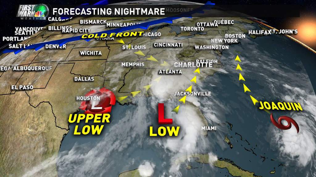
All kinds of moisture over the eastern seaboard during most of this week. Not sure how it will play out yet but it needs to be watched!
 Bryan_NC
 Hi Bryan! Long time no see. I hope all is well with you and your family. Thanks for the heads up on this.
 Calico696
 Hi Calico. Thanks everything is good down here. Great summer. Guess I will try to pop in for the big stuff in the weather dept LOL. Hope you guys are all good up there also!
Bryan, thanks for checking in with us. Sounds like you're happy with your move to NC. When will we have a better idea of how this is going to go?
 Bessie
  Dansker
 Right now it looks like it comes in 2 main waves. First being Tues/Weds and then Tropical Storm Joaquin Fri thru Sunday-ish.
Hey Bryan_NC, was wondering where you have been. Hope all is well in NC. Need you for the upcoming winter. Need to be kept updated. LOL!
 botheredbyuu2
  Mom of 1&1
 As soon as I saw this weather thread, I thought about Bryan's helpful updates:)
Thanks for checking in!
 Blackcat
  Lady Jayne
 Thanks Bryan! Outdoor wedding in our family Oct 4th.. so please use your contacts to tell Joaquin to either hurry up or wait! :-)
 hktownie
 Wishing they did some drainage improvement on east stiger.....hopefully we don't flood!
 Darrin
 I guess best way to explain what the models show now is that we (well you guys) should experience legit tropical storm like conditions from Fri to Sun. The duration of that is probably what should scare you the most. This has 5-10+" rain potential over a very widespread area.
 Weebiekins
 Bryan, do you see this storm affecting flights from Newark at all? Our first trip to Disney and now a tropical storm!
 3wbdwnj
 Depending on the timing this system would have major impacts from eastern NC all the way up into Canada. So yeh i would think everything would be affected somehow.
I'm glad the Pope got in and out before this coming weather!
So happy to see our very own, HL- best ever - meteorologist, Bryan, back to help us out. Did anyone mention we missed you !
 Spring Fever
 haha thanks. I think i missed tracking real weather. It's been so quiet for the last 6 months!
I'm actually looking forward to the rain. It's been way too dry. However, I hope the flooding is kept to a minimum. Any chance that this could strengthen to a hurricane or will it just stay a tropical storm?
I don't see it being a hurricane up there. Probably more like a hybrid nor-easter tropical storm. It's not as strong or as organized as Sandy was. However it is coming west because of some major blocking (like Sandy did). So whether the actual low center stays east or not (most likely it would for the most part), the affects can be still major.
It's been dry all right, although it poured for Hackettstown's opening football game.
 Andy Loigu
 Rut roh Rorge! This is from NJ.com on the storm.
http://www.nj.com/weather/index.ssf/2015/09/tropical_storm_joaquin_could_strike_nj_pose_biggest_threat_since_sandy.html
We really need some water. But not to the level that it's another dangerous deluge. I'd rather it be far lighter but drag on for 4-5 days than just one big shot.
 GC
GC Well sure...hasn't rained in weeks, and it's my first time ever going away overnight and leaving my children for a wedding in Long Island...so naturally we're getting a tropical storm. Yippie!
 Tracy
Tracy  JRT
JRT It will be OK Tracy. Been there, done that and although it's not easy for a mom to feel comfortable away from her kids, it all works out well. No worries. ; )
 Htown746
Welcome back Bryan! Happen to catch the latest GFS model tonight? Nuts! Capturing and pulling Joaquin back west into the midatlantic of NC and Virginia with nearly 30 inches of rain in spots. Are you under the gun with this in your immediate area of NC?
Of course it's only one model run and will likely continue to flip flop in the days ahead as the event gets fine tuned.
 Vic
Vic  dsl102927
 Hi everyone - thanks!
Vic - it keeps trending a bit south. I could possibly be on the southern edge of all this as of now.
I've never seen more features on a map. It's insane. The details will change quite a bit over the next few days but the bottom line is to stay on top of it because it could really turn into a dangerous situation (hope not).
Bryan now you're scaring me. Are you thinking dangerous for our local area, or dangerous for a large part of the northeast?
Darn! Every time I try to go fishing, there is either a trickle or a flood. The weather is getting worse every year.
 sparksjbc1964
 Hope its not going to be another Sandy. People are still homeless after that storm and its almost 3 years. People are paying a mortgage on a house that's no longer livable or no longer standing AND paying rent to live somewhere else. Not being able to afford to do both, some are losing their homes to foreclosure. Now their credit takes a hit and at NO fault of their own. This should have never have happened. Makes me so angry. Where is a great leader, Chris Christie???
I agree, byuu2. And with the "due diligence " laws on repairs, gives only 6 months to make the home livable again. So of course the " not so rich " have to walk away, the insurance companies don't pay, and the banks get the houses back. It's really obvious, when you go to the shore, to see the real "have and have not's". There was something on Frontline or 60 minutes (was a while back) that showed how the insurance companies were defrauding the policy holders. Christie can't be found right now.... he needs to replenish his calories from campaigning.
Hate what i'm seeing now. Looks like it would probably stay a hurricane and make landfall somewhere in SE VA. Luckily for us but still major affects for everyone. It would come west exactly like Sandy did. Very dangerous situation. Needs to be watched up and down the coast.
God, I hope not. We had $6000 in damages from Sandy. The insurance company gave us a stinking $2500 back.... prorated I guess. Home depot doesn't sell prorated building materials. That was my first claim, after 20 years and $14k already given to those greedy, predatory capitalists! Jersey is an insurance and banking playground.
Stay safe and thanks for the updates, Bryan.
The Euro may be our last hope. It does still take it farther east. I believe the GFS may be the farthest west of the models.
Uh oh! It's a hurricane and it's headed our way. Help Bryan!
http://patch.com/new-jersey/longvalley/breaking-joaquin-becomes-hurricane-expected-head-toward-nj?utm_source=alert-breakingnews&utm_medium=email&utm_term=police%20%26%20fire&utm_campaign=alert
I believe the next run of the Euro model is early this afternoon. Should be interesting to see if it comes west and joins just about ALL of the other models wanting to pull Hurricane Joaquin west.
What's the deal with all of the panic and concern? Every hurricane that hits the U.S. isn't going to be a Sandy. Yes, I was without power for Sandy (like everyone else) but I haven't heard one thing about this storm that implies it will be anything like Sandy and therefore, perplexed by all of the concern.
 emaxxman
 From what I have heard, flooding will be the major concern with this one as opposed to damaging winds etc.
emaxx - i don't want to go overboard with this but there are definitely similarities with the upper pattern. It's too scary for me to even think about. Every storm is different and believe me i'm not really the expert on this. But what i see now is scary to me...
http://www.nhc.noaa.gov/graphics_at1.shtml?5-daynl?large#contents

Here is an update from Eastern PA Weather Authority's Facebook page.
With the 11am update from the National Hurricane Center, Hurricane #Joaquin is now a formidable category 1 hurricane at 80mph. New advisory changes in the latest update takes this to a major hurricane (category 3) before weakening to cat 1/cat 2 as it approaches landfall. The forecast track also takes aim at southern New Jersey, but no disrespect to the NHC, we're not convinced that will be the correct solution. We will continue to closely monitor Hurricane Joaquin's progress over the next couple of days and update daily publicly and on the forum constantly. If there is nothing else you take from this post other than this, there is absolutely no reason to panic right now anywhere in our coverage area until tracks get sorted out!
https://www.facebook.com/easternpaweatherauthority
I really hope it misses us... either way this just pushed me to the decision of a whole house generator.
 Forcefed4door
  ianimal
 Thanks peeps. I didn't mean to diminish the potential for damage. I have my neighbor's tree close to the house and above 1/2 of the driveway. I moved the cars to one side last night as a precaution. Just don't seem as worried as we did with Sandy. Probably naivete on my part.
That 11AM update was sobering. POTENTIAL for a major hurricane just SE of Cape May NJ by 8AM Monday morning. Scary indeed...
Nah, not naiveté'... they were selling Sandy as the "storm of the century", and it turned out they were pretty much right.... one time out of 50 isn't a very good batting average, but...
You know the media- they love train wrecks. They're hoping and praying this turns into a train wreck. They're going to sell it for all it's worth.
 JeffersonRepub
 I guess my main takeaway from this right now is there is a definite model spread on where this thing will be 5 days from now. And of course 5 days out things can change with any storm. So we can be hopeful that this thing doesn't make that sudden left hook into the coast like some models now show. Even so there can still be major affects though.
It is always prudent to be prepared for the worst possible scenario.
However, whenever we dodge a bullet, people complain about weather forecasting and the media --- rather than thanking The Lord that a potential disaster missed us.
People just don't know how to be happy, I suppose.
Big trend south on the GFS that just ran. Basically NC/SC border and then pretty much a stall. Wow. Don't want that.
 MeisterNJ
 Oh geez Meister! You just reminded me of that nightmare. My normal shopping day is Friday, so I think I should be ok. I wouldn't want to be in the stores on Saturday or Sunday this weekend if the forecast stays on the present track. I actually think I might hit the liquor store on my way home today to be ahead of the game. ;-)
The euro just ran and it still wants to hook it farther out to sea after it hits Bahamas. So still up in the air I would say.
I think we will see weather the GFS model petraflops or not.......
Upgrade in Jan so far untested in H-cane season; next upgrade any day now.......
http://www.noaanews.noaa.gov/stories2015/20150105_supercomputer.html
Not sure last winter told us much about upgrade effectiveness.
 strangerdanger
 Calico if you go to liquor store today. You will have to go again by Saturday. Who are you kidding????
 CraftBeerBob
 LOL Bob. Actually I'm pretty well stocked already. I would be making this run for double reinforcements.
I have a buddy who is supposed to be leaving out of NYC for a cruise to the Bahamas at 1pm Sunday. I'm guessing the boat won't be leaving port?
I bet a certain governor would be pretty happy if he could show how great he was by walking around with victims...
 1988LJ
 Ianimal, I have a friend that's on the same cruise if its on Norwegian. Sad for them if it gets messed up.
NHC is throwing out the Euro, they claim bad data. OBX looks to be the current main target. There are other factors here though including a noreaster like trough developing north of the hurricane. So while I might say things are looking a bit better for northern NJ, there are still plenty of things that can make this a bad storm.
btw - winds now up to 105 mph and pressure steadily dropping. Would think this is a cat 3 by morning.
Calico, I love Bermuda too! Glad our cruise was 2 weeks ago with no hurricanes brewing in the Atlantic.
That's awesome Bessie. Although I am anti-cruse (too many people), Bermuda is one of my favorite places on earth! St. John, USVI is my heaven on earth!
Thanks so much Bryan , great to hear you are looking out for us. But this storm may hit closer to you ? Are you near the coast or more inland?
 just coach
 Well the GFS is trending back north and now even east this morning. Euro holds on to it's out to sea solution. This is crazy. I have no clue what's going to happen and the models are having major difficulty with this.
Bryan, what is the timing on this? I realize it will vary greatly, but can we rule out Saturday? Thanks for your help!
LET'S ALL FREAK OUT!!!!!!!!!!!!! All you need to do is be prepared. Nothing you can do to control the weather.
 buffy
buffy I dont think anyone is freaking out buffy, we just want to keep on top of the pattern so we CAN be prepared to change our weekend plans. Or to get gas for the generator if that's what it comes to. Just staying informed.
Nobody's trying to control the weather here buffy. All we're doing is trying to get a better idea of what to expect so we can be prepared.
Luckily, even if power is lost, at least it's not freezing temperatures like it was for the ice storm. And I forget- was it that cold when Sandy hit? Had we turned on the heat yet? lol
A little food, maybe some water if you have a well pump. Gas for the generator IF the storm takes a turn for the worse.
Alcohol stays stocked up for the apocalypse, so don't need to worry about that...
Forecasts are all over the place. A few minutes ago a major network weather was saying that it appeared that it would move east into Atlantic. Few minuted later the Patch says it's headed towards Delaware with significant impact to NJ:
http://patch.com/new-jersey/longvalley/breaking-hurricane-joaquin-strengthens-major-impact-nj-expected
 OnTheEdge
 Jeff, if I remember correctly, it was cold, in fact it snowed while we finally got a room in a hotel. The house got down to 40 and it was rough. After dealing with that cold for 5 days, we finally found a hotel room available. Standby generator installed soon after.
 justwondering
 Some of what you guys are seeing is old informatoin. Last night's GFS was insane. It was Sandy all over again. The full GFS hasn't run again since then so there could be old data out there. I would expect a big shift to the east on the next run in 3 hours.
It was chilly post Sandy. Had the wood stove going 24/7. Just won't try to heat tomato soup on it again. And now I remembered I have a propane camping stove;) I had to use that to finish Thanksgiving dinner last year when we lost power along with the grill.
Yeah, it was relatively warm when Sandy hit, but highs plummeted into the 40s for at least a week after the witch blew through.
A week after Sandy there was snow, even down the shore. Enough to plow actually. I actually see more tranquil weather after this and eventually even a warmup.
News 12 NJ News/ Weather on tv just commented on the unreliability of any of the "NJ Patches " weather forcasts at this time. They are creating fear rather than any kind of
reliable trending of the storm. It's too soon to make the statements they are putting out...Don't shoot me, I'm. Just the messanger. ; )
Here's the official NHC track as of 11 am. It continues an east trend from last night...
http://www.nhc.noaa.gov/graphics_at1.shtml?5-daynl?large#contents
Hey Bessie,
East would be great, because the storm would go out to sea and then die over the North Atlantic.
 davedigsducats
 Andrew's Mom
  maja
maja 
I have tickets and reservations in Atlantic City on Saturday. Now that Governor Christie has declared a state of emergency I wonder how this will affect our plans?
Hackettstown PD has cancelled the Community Day scheduled for this Saturday in Lowe's parking lot.
http://www.lehighvalleylive.com/warren-county/index.ssf/2015/10/hackettstown_cancels_community.html#incart_river_home
Category 4, went on lunch to Shoprite (wharton) already a mobbed. Took 15 minutes to check out with my chinese food.
 youngen
 Oh NO, I just wanted to maybe get a roaster chicken from SR tonight. Now I wonder f it'll take 1/2 hour to get out of there with it - LOL!
 Phil D.
 The 5pm has the cone moving east, however the center still hits NJ. The actual major models don't show a U.S. landfall.
The voice track says "well the GFS and Euro model lines are on the right/east of the cone without a US landfall but we don't move the cone all the way until a couple of model runs"
That's right kids, "pay no attention to the models behind that curtain." If we move the cone too fast we will look like idiots.
Idiots.
Still gonna be rough on the coast even if the storm does not make landfall.
I'm still very confused-is there or is there not going to be a major hurricane? Will we have another Irene, or another sandy? Could it be something much "worse" or something much "better"?
Can someone explain? I'm terrible at interpreting weather forecasts...
So is it safe to say we know as much now as we did before a State of Emergency was declared...I have no idea what's going on with the weather.
Remember. The fact the models moved east does not stop them from moving west. The "cones" still have it making landfall in NJ so be vigilent. We have some time and nany modems go go.
The cone has not had NJ in the center since early this morning. The NWS/NHC does not drastically change their forecasts based on 1 model run. That makes all the sense in the world. Models are for guidance not forecasts. I guess I understand the confusion but the part of the track that has changed is the part that was 3 days out or more. So it's not like a bust here.
Bottom line - there will be rain in Nj and coastal erosion but nothing major in the way of wind or rain at this point.
Just to add - these affects will last until early Tues morning as it stands now.
What is actually a little concerning to me is it is still moving SW when it should have taken a turn hours ago. So I won't be taking my eye off this yet.
Thanks Bryan! Do you know about any kind of percentage of us getting hit severely? I heard 70% at work today, it may just be a rumor.
10%
When I post things on here, it's always the absolute latest information that can possibly be available. Other sources might be looking at models from 6-12 hours ago. Especially these random news sites and channels.
Did anyone else use The Edge weather site? Surprisingly he was dead on woth this storm days ago. Gotta give him credit, defintely the first place i go when i hear bad weather is on the way.
Models shifted west overnight but still offshore so no worried at this point. If your model of choice was the Euro then you probably look like a genius. Let's not forget the euro predicted 4 feet of snow in early Feb and we know how that worked out. It is the best model overall though I don't disagree.
 joyful
 Hello Townies! Check National Weather Service Mt Holly - Has Joaquin moving more east than what we saw yesterday.
Be prepared and keep praying!
 MAN
MAN I bet those poor people in the Bahamas don't care what direction he heads in... as long as he leaves. He's been hanging around down there for a week, like the mother-in-law from hell, lol.
"The cone has not had NJ in the center since early this morning." Strange Bryan, I was using TWC and not only did the cone center on the NE and NJ at 5 pm but the talk track was exactly as I portrayed.
This morning they noted that the cone had shifted east to no landfall and now add a Euro/GFS average trend line on the east edge of the cone. It's like a cone with a candy edge.
I do understand not moving the cone after a single model run but found the commentary funny. You can bet they would have moved the cone west on a single run and skipped the commentary.......
Where the heck did they get the name for this event???
Good name for a spelling bee!
Why ( in my opinion ) don't they just give an Storm event a Number? or I.D. instead of a Name.
Like for instance ..... S 10-2015 #1. ( Storm MM - YYYY Storm I.D # ) etc.
 Embryodad
 They used to just give hurricanes girls' names, saying (I actually heard this on ABC radio when I was young) ... because hurricanes and women both are unpredictable.
Since they were under fire for this being politically incorrect, they eventually started mixing boys' names into the rotation.
I remember saying, in 1992, when Hurricane Andrew did serious damage in South Florida... well, if you're going to name a hurricane Andrew, you know it's not going to be some wimpy hurricane.
Reposting Bryan's link from above:
http://www.nhc.noaa.gov/graphics_at1.shtml?5-daynl?large#contents
The track seems to be a little further east than I remember the Euro model showing a couple days ago, but pretty close. What do you think Bryan, is the Euro model finally emerging as being more accurate than the others, at least when it comes to hurricanes?
 justintime
 IMO, and others, the euro model is more accurate but frankly it's the funding. They invested, we did not. The GFS has seen a number of improvements since Sandy and will increase processing power by Petra flops this month.
Will still need a few seasons of testing in the real world, but the GFS model should be getting better by leaps and Petra flops.
 matt
matt No matt. This will be way offshore. Will get rain and some wind, but nothing too serious. The coastline will probably see some erosion as well.
Yes in this case and in quite a few others the Euro is the winner. It was much more heavily funded than the GFS although the GFS has improved as Stranger said. I believe a conglomerate of countries actually invested in the Euro and it has a lot more data points, better algorithms and is much faster.
The Euro has a lot of "cred," as they say on the streets.
A lot of sincere prayer may have pushed that storm out to sea, too.
PTL.
Hackettstown has only had 0.73" of rain the past 3 days. Much heavier over NE NJ and South Jersey. Temp down to 44F this morning. Turn on the heat.
Andy-Not quite what I was praying for! In-laws coming Monday and I was hoping for a miracle ;)
 Bonv
Bonv 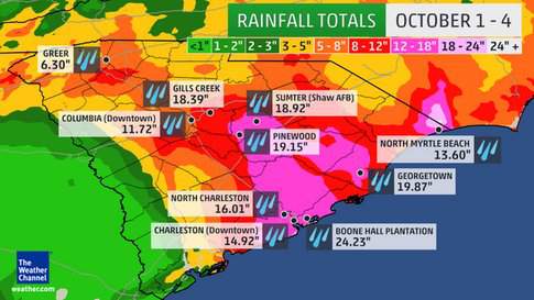
I had a lot of rain but an hour south of me and it's catastrophic...
http://www.weather.com/safety/floods/news/south-carolina-flooding-impacts-0
 Mrs. Pipes
 Glad you're all ok Bryan..terrible what the people are going through with all that rain.
Last week's weather time lapse in 7 seconds:
https://www.facebook.com/NWS/videos/10154326165029041/
I knew Bryan was OK once I texted my bSis and found out she and her family were good. Yes CBS New York was interviewing people and did a story on the container ship lost with 33 on board, 28 American and 5 Polish Sailors. A tragic loss there as well as the 13 (last time I saw) confirmed dead in SC.
I have to agree with Colbert's comments last night about it, one of which was about people going from the idea of "a thousand year storm" to "the State hasn't seen this kind of flooding in a thousand years". He was only pointing out how people were making a ridiculous jump, but he did show a clip of a graphic from the storm that showed how SC got it bad from a distance. The storm just kind of reached out and really touched his home state in a BAD way!
Commenting is no longer available.