2014 Thunderstorm Thread
Let's use this thread to report "severe" thunderstorm weather.
Warren County (and the entirety of NJ) is currently under a severe thunderstorm watch until 8:00 pm this evening.
Parts of eastern PA are under a severe thunderstorm warning, so that could change NJ to a warning rather than a watch.
Be careful out there.
 Calico696
  Andy Loigu
  just coach
 I feel like we keep getting skipped over...was looking forward to a good thunderstorm today.....
 josepcan
  NJKID1010
 I came off of Rt. 80 in Mt. Olive around 10:30 this morning and just as I did it started raining so hard you could barely see the road in front of you. Kept up like that the entire way down 46 until I got to the A&P. Luckily there wasn't too much traffic. It was coming down in absolute buckets.
 Tracy
Tracy @Tracy
I was in Netcong at that hour and got soaked just running back to my car! It was intense!
 Mr Negative
 This scattered stuff is why people get mad at weather forecasters.
I've been in Washington (Warren County) all day and it barely spit. The last two hours it has been bright sunshine, took a nice walk.
Tracy, I was in the same area and had the same experience you had with the buckets of heavy rain. I was driving West from Succasunna and deciding if I should pick up 80 or take 46. When it started raining I decided to take 46, and I'm glad I did. Like you said, it was absolute buckets of rain, and I could not drive safely because I could barely see in front of me. I pulled into a parking lot and waited until it subsided.
 Mrs. Pipes
 Pretty intense storm here (northern Lk Hopat) around 5pm. Came with some decent chunks of hail too. Also had a storm late last night.
 Bryan
Bryan I heard the thunder from that storm at 5. We were over at ITC. Just sunshine over there.
 Blackcat
 Severe storms approaching as just coach mentioned:
http://forecast.weather.gov/wwamap/wwatxtget.php?cwa=phi&wwa=severe%20thunderstorm%20warning
 Vic
Vic Andy-same here in P Murray. Dark clouds circled us, but barely anything came from them. Seems to happen like that often, because we are down in the valley. Thats ok with me. :)
 botheredbyuu2
 I remember watching a high school baseball game, that was played in bright sunshine, while there were black clouds to the north and big lightning bolts ... I remember saying out loud, to anybody who would listen ... Blairstown must be getting hammered.
THunder storm forecast today listed as strong or could be severe. Accu weather hourly reports t- storm at 4:00. 7:00. I think again at 10:00 and 1:00. Something like that. Looks like several possibilities for some good rumbles of thunder. Never get tired of it.
Was a disappointing dud as far as rains here today. Was hoping for a quick good soaking rain for the garden. South Jersey was today's winner.
I don't always go to Wal-Mart, but when I do, I make sure there's a downpour happening when I come out.
 Rebecka
  ianimal
 I really think Washington is the black hole....skipped over again with thunderstorms....bummer
Yeah was just looking at the radar too...rain sliding juuuuuuust to our north and storms popping I78 and south. Looks like we won't even get a drop. Shame too as we could really use the rain.
It got dark, it might have rained for 10 seconds. Is that it for the day? The plants really need a soaking and we got barely a spit.
 maja
maja We heard thunder and not a drop of rain. Now tomorrow they say it will rain all day.
 Christine
 It's not gonna rain all day tomorrow. Steady rain late tonight with a few rumbles of thunder before tapering off during Thurs morning. Some breaks and improving conditions in the PM with a small chance of a shower or storm later on.
No rain for us here. Thanks Bryan. All day I thought it was Wednesday. Thursday they are calling for rain all day. I have to get my days straight! LOL.
"I have to get my days straight! LOL"
this is true and i myself struggle with this on a daily basis -
today will be today all day long, tomorrow will be today when it gets here, again expect today to last about 24 hours or so before tomorrow becomes today again.
today will become yesterday as soon as tomorrow becomes today.
fully expect this pattern to repeat over time. (must be global warming)
 BrotherDog
 thanks for that clarification, BrotherDog - I hope you don't mind if I copy and print it ....excellent indeed - lol
 5catmom
 Ch 5, rain late tonight (heavy at times) into tomorrow about noon. Then clearing out. Nice for Fri, Sat and Sun.
Yes, we need some rain. I miss the cooler 65F days we recently had. That was perfect weather. Finally had to turn on the A/C.
 emaxxman
 No thunderstorms this coming weekend.
From Eastern PA Weather Authority's FB page:
***EPAWA ALERT: BLISSFULLY FABULOUS WEATHER INCOMING FOR THE 2ND STRAIGHT WEEKEND***
The period from Friday through Sunday will be rain free with lower humidity... temperatures slightly above normal in the 80-85° range and slightly above last weekend's highs... pool and picnic and outdoors weather over the weekend. Full details for your local area at http://epawablogs.com/epawa-daily-regional-forecasts/
FAntastic weather for Saturday's race - final leg of the Triple Crown Belmont Stakes. We will be there cheering for California Chrome who could be the first Champion in 36 years. Go Chrome.
You know, "it ain't the heat, it's the humidity....." but yet finding a humidity forecast is difficult much less an easy forecast "it's gonna be humid five days from now dum dum....." which is need since humidity is sort of relative and changes hour by hour.
So today when I emerged to a wet blast, you know some of it will "burn off" during the day with the sun.
Plus on some days and some temps, 60% humidity is humid, sometimes not.
So, anyone know of an easy place to see humidity forecasts for 10-days out. On the weather channel you have to go day by day in expanded mode. Plus, would like a site that does more than show the average, since today the humidity will changes by 30 points or more during the day, averages are kind of misleading.
And lastly, some sort of "discomfort" reading since the same humidity reading can be OK or discomforting depending on other factors like temperature.
Just asking since I hate to miss those dryer days.
 mistergoogle
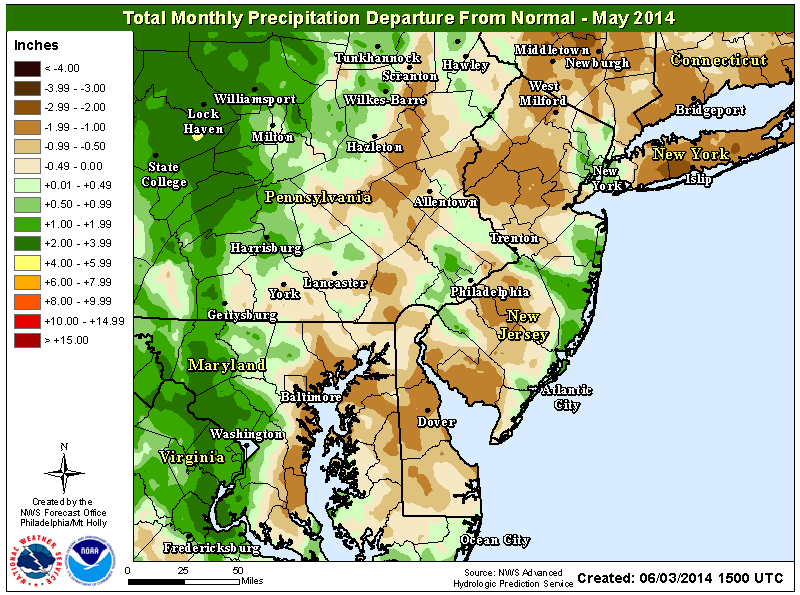
I thought so. What a dry May it was.
Map shows the haves and have nots with respect to rain during the just concluded month of May.
Storms are coming. Lots of thunder here in Oxford with some lightning. Just started to rain a little.
 Embryodad
 Just saw the Tin Man fly by the window.....Oh No! There goes Todo...
Don't step on Todos Tail !!!
Was at Costco when the sky turned dark. Lightning was insane. Got to drive to Short Hills in the downpour and home in it. Awesome...not!
That was some storm....I left Roseland at 4:15 and drove directly into it. Was at the top of the hill between the mountains on Rt. 80 in Denville watching the lightening right over us and the rain just sheeting down. We weren't really moving, so it wasn't so bad. Once we got into Dover/Rockaway it was all finished.
In Mansfield, too... can't believe all this rain we're getting. What a soggy week we've had.

Now THAT was a Proper storm!
At 3:45p the view east over Schooley's Mtn. was a mix of mare’s tails, very tall thunderheads and a dark fast-moving encroaching pack of Heavy Weather ... just wild. The rain gauge reading at Hang Glide Central, Rockport Rd. area, was 1.75" in a v-e-r-y short period of time.
 redmink1
Is there a site where we can find out how much rain we've gotten in the past week or so?
Rebecka, I don't have a rain gauge so I've searched for something accurate and close to home ... you want temp and wind? It's handier info than rain!
Outside of using WunderMap and and checking at various times of the day and doing my own adding, Rutgers provides this:
http://www.njweather.org/data/daily/3398
It'd probably be easier just to get a rain gauge.
Was just putting the garbage out here in Oxford and saw lightning but it wasn't followed by any thunder. Was surprised since I know there is no rain in the forecast tonight. Just looked at the radar and see a big storm sliding just south of Allentown PA at this hour:
http://radar.weather.gov/radar.php?rid=DIX&product=NCR&overlay=11101111&loop=yes
Hard to believe it could have been from that so far away.
Redmink - thanks so much, that's exactly what I was looking for!
Maybe just heat lightening, Vic?
Rebecka, just had to research the true meaning of heat lightning. Yes, I suppose we can actually call it heat lightning then associated with that thunderstorm cell around Allentown PA earlier last night. Saw the flashes but never heard any thunder:
http://en.wikipedia.org/wiki/Heat_lightning
FYI --- heat lightning is lightning, just far far away. http://en.wikipedia.org/wiki/Heat_lightning

Another interesting night of heat lightning in the area. Looking out to the NW, the sky is beginning to light up. Looks like I'm seeing storms that are moving through from Upstate NY north of Monticello, NY nearly 100 miles way. Pretty amazing.
The picture of the sun that was showing for the 4th of July weather has, sadly, disappeared. Storms from the west and along the coast. It's my day off Mother Nature! Throw us some sunshine please.
No doubt the 2nd half of the week will be rainier than the 1st half. But most of Friday will really depend on the track of what will become TS Arthur (also predicted to become a hurricane). We need the cold front to kick it just a bit farther east for Friday's weather to improve. There is still time.
http://www.nhc.noaa.gov/graphics_at1.shtml?5day?large#contents
Yikes! That might be worth starting a thread about Bryan. Lots of people vacationing in that area this time of year.
I don't want anything dangerous, but please, please, please at least a little rain because it's just too dry right now.
 GC
GC Sat and Sun suppose to be real nice. Move the festivities off Friday and ENJOY the rest of the weekend.
I am surprised that no one has posted yet! It is getting really dark and breezy here in Hope. My phone keeps going off with all the severe weather alerts!
 just saying is all
 just saying is all - It's very localized if you watch the radar. That may have been what you saw, but where I am in Hackettstown we've had nothing at all. Hardly a slightly gray cloud.
I see the scary dark clouds to the north, but all is calm here in Washington, in the Musconetcong Valley right now. Waiting to see how this will affect tonight's IronPigs' game.
 fussylady
 We had some thunder and a brief shower (in Mansfield) about an hour or so ago. Now it looks like another bout is coming our way?

 EG_1982
Scary-looking indeed, EG. They look like they're about to unleash fury in the skies.
Decent looking line of storms in PA moving into Warren County. NWS Mount Holly has just issued a Severe Thunderstorm Warning in the Poconos for these storms. Will be interesting to see if they can hold together and reach our area.
http://radar.weather.gov/radar.php?rid=DIX&product=NCR&overlay=11101111&loop=yes
 kayaking
 holy crap what a storm ---thought it was going to pass through but - maybe not so fast
Middle of the night in PM for about 20 mins. I hate the crackling thunder. Always think something is getting hit by lightning :{
Severe Thunderstorm Watches posted for almost the entire state moments ago until 11PM tonight.
http://forecast.weather.gov/showsigwx.php?warnzone=NJZ007&warncounty=NJC041&firewxzone=NJZ007&local_place1=2%20Miles%20ENE%20Delaware%20NJ&product1=Severe+Thunderstorm+Watch&lat=40.89595&lon=-75.00737#.U7xeEvldWSo
I'm going to need to put a pet bed behind the washer and dryer. It's been about 5 days now since the End of Days was declared.
I am very lucky in that our current pet (Indy the greyhound) is not bothered at all by thunder or fireworks. But the icemaker in the door of the fridge- OH NO!!! It's the ICE MONSTER!!!!
I feel bad for the ones who have so much trouble with the loud noises, there's really nothing to be done unfortunately.
 JeffersonRepub
 All my "kids" are good around basically every noise know to man. Two of my cats don't like the vacuum, but Sabrina and Daisy don't have an issue with it. Those two just go under the bed until I shut it off, then come back out. Everything else is taken in stride.
Just looked at the radar. Pretty ominous! THEY'RE COMING!!!!
Sent: 20:56 EDT on 07-08-2014
Effective: 20:56 EDT on 07-08-2014
Expires: 22:45 EDT on 07-08-2014
Event: Severe Thunderstorm Warning
Alert:
THE NATIONAL WEATHER SERVICE IN MOUNT HOLLY NJ HAS ISSUED A
* SEVERE THUNDERSTORM WARNING FOR...
WARREN COUNTY IN NORTHWEST NEW JERSEY...
HUNTERDON COUNTY IN NORTHWEST NEW JERSEY...
MERCER COUNTY IN CENTRAL NEW JERSEY...
MORRIS COUNTY IN NORTHERN NEW JERSEY...
SOMERSET COUNTY IN NORTHERN NEW JERSEY...
SUSSEX COUNTY IN NORTHWEST NEW JERSEY...
MIDDLESEX COUNTY IN NORTHERN NEW JERSEY...
* UNTIL 1045 PM EDT
Target Area:
Hunterdon
Mercer
Middlesex
Morris
Somerset
Sussex
Warren
More: http://alerts.weather.gov/cap/wwacapget.php?x=NJ12515FCE4920.SevereThunderstormWarning.12515FCE92F4NJ.PHISVRPHI.05880d5f1249da7dda4dd0add8bdcb8b
 LeRoy Grimace
  Mariann
  Dave G
 Reports of power outages down in Easton, PA. Worrying about my two weeping willow trees in the backyard. Heard branches snapping about two minutes ago with a strong gust.
Big time traffic problems around the County per the First Responder site mostly due to tree limbs and wires down:
http://www.wcpublicsafety.com/firstresponder/wc911/recframe.html
The wind was horrible - Super Storm Sandy-like (at least for us in the center of Hackettstown). I really thought that the 2 trees over the house were going down. The beach ball from the pool ended up in the front lawn - wind brought it over the house and fence !? Hope everyone stays safe tonight.
 Bonv
Bonv  jophus
  smilingbecs
  CR37
CR37  Mark Mc.
  Bessie
 Checked JCP&L and showing >1500 customers affected. No ETA . Just a status of pending investigation and awaiting dispatch.
 JayP831
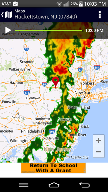
Looks like the storm has past. See my image attached. In play mode, it was moving north east.
 Challah
 Just got this from the Police Department, through Nixle.com
Advisory: Power outage
Bilby Rd and Hight St area's are experiencing a power outage from the storm. JCP&L is aware. No power:1-888-544-4877
Haven't seen any estimates yet.
 Derek
Derek  Phil D.
 That was a stupid storm, just some wind and lightening far off in the distance
Hmphhhhh
 H-town Mama
  Brendan
 Our gutters were overflowing and the driveway looked like a river for about ten minutes. Some downpour that was. No hail that I saw here in Mansfield, though. We've had our share of thunderstorms these past few days! (Poor Sugar behind the washing machine!)
We just lost power and JCPL are reporting tomorrow morning at 10am for the power to be restored!!!
 Baci's mom
 Sugar actually went to the Land of Stray Fuzzballs but came out again not too long after. She's a Jeopardy fan and didn't want to miss it. ;-)
 jrsemom
 Looks like our immediate area did very well in the rain dept yesterday with a good soaking rain. Hackettstown and Pequest Fish Hatchery scored about 1.25 inches in the bucket. A little less in Hope at around .75.
I don't mind all of this rain as long as we don't have severely high and damaging winds (yes, I know that we've had them too.) A good 1" soaking in a short time with nice weather during the day is great. You can enjoy your day outside while getting the necessary water the plants need.
emaxxman - That's exactly what I placed my order for. Thorough drenching, but only over night. No big wind, hail, or other chance of damage. And certainly no thunder.
Here comes the latest afternoon cloud through the Lehigh Valley headed our way. Lehighton got it first yesterday, and today New Tripoli is the epicenter. Please. I'm serous. Please spare my cat. She's not a happy person at night now. I'll end up with either claw marks from the sudden noises, or burn marks from where she holds on so tight she refused to let go. This is not a clinging type of cat.
Probably 45 mins away from the "isolated pocket". How about you go isolate yourself somewhere else. ;-)
GC-no one could have said it better. Lol!
The first clap of thunder, the animals disappear.
My kitties are not scared - perhaps they should be but they're not ---for them it's just another time for a nap

I tried to help my sister hold it together even with one distance rumble. Then a closer one came by and she yells "F U All !!!!!!!!!!" and runs behind the washing machine. Another sleepless night for moi....
So cute, GC.
Today's storm was exactly the same time as yesterday. Today Lucky climbed up behind me in the chair and shook like a leaf. Poor little thing.
the 10 day weather report has " potential for severe thunderstorms" for Monday AND Tuesday. Interesting !!!
This week has been pretty wet. I'm sure I've had well over 2 inches of rain this week and over 3 since last Thurs when we had the huge hail.
Believe it or not it looks like a piece of that polar vortex is coming down again. Pretty odd for the middle of summer. It will mostly affect the Midwest but we will feel some affects. That's what will cause more storms, most likely, the 1st part of the week. After that 75-80 temps for a while and 50s at night. So it's not such a bad thing now I would say.
Thanks for the update, Bryan. Always nice when we can turn off the A/C and have the windows open at night. Funny to hear the word "polar" in July! :-)
Saying the pattern change that is forecasted to occur later this week is due to a "piece of that polar vortex is coming down again" is incorrect. Just because a very cool weather pattern sets in, does not mean the polar vortex has dropped south in the middle of summer. Read the American Meteorological Society Glossary to understand exactly what a polar vortex is -
http://glossary.ametsoc.org/wiki/Polar_vortex
"A planetary-scale mid- to high-latitude circumpolar cyclonic circulation, extending from the middle troposphere to the stratosphere. The Northern Hemisphere vortex often features two centers—one near Baffin Island and the other over northeast Siberia—with analogous circumpolar asymmetry atypical in the Southern Hemisphere. The westerly airflow is largely a manifestation of the thermal wind above the polar frontal zone of middle and subpolar latitudes. The vortex is strongest during the winter in the upper troposphere and stratosphere when the pole-to-equator temperature gradient is strongest. The stratosphere component of the circulation may be referred to separately as the “polar stratospheric vortex.” In summer, the strongest westerly circulation is largely confined to the troposphere, and the polar stratospheric vortex reverses in the upper stratosphere because of solar heating during the polar day."
In other words, as the Weather Channel explained on its site, "Laying the blame for this anomalously cold outbreak of air on the polar vortex is incorrect -- this air bubble is in an altitude much lower than where the polar vortex is located."
BLD - you should reference the post where you copied your information from: http://www.nynjpaweather.com/2014/07/10/the-polar-vortex-debacle-example-of-bad-meteorology/
I thought it was supposed to rain today. I was working in my driveway and even though it wasn't blazing hot temp-wise, the humidity was really gross. It was like working in wet clothes.
It's coming emaxxman. Severe Thunderstorm Watches are up for much of PA, excluding the Lehigh Valley currently, along with a Tornado Warning thrown into the mix at this hour for Sullivan County in NY.
There was only a 30% ch of storms today. Overall we should see quite a bit of them the next 48 hours though.
The latest from NWS Mt Holly's Facebook page concerning tonight's weather:
https://www.facebook.com/US.NationalWeatherService.PHI.gov?hc_location=timeline
"Tonight's strong thunderstorm potential in Eastern Pa and Western NJ:
Based on upstream radar extrapolation and the HRRR rapid update model maintaining the strength of the band of strong storms upstream in central Pennsylvania, we are expecting a band of at least scattered heavy thunderstorms with gusty west winds to move into the Poconos between 815 and 915 PM, then progress eastward to the Interstate 95 corridor between 11 PM and 1230 AM.
Some of the storms will be rather strong with potential for 50 mph wind gusts, lightning strikes and wind taking down a few tree limbs and possibly blocking a few roads. This band should decay as it reaches the NJ coast around 2 am.
The greatest risk for strong storms with scattered power outages appears to lie from east central Pennsylvania near Reading, northeastward to the Lehigh valley and Poconos into west central and northwest NJ before midnight.
Rainfall could easily total 1 inch in 30 minutes in several locations of eastern PA and western NJ.
Those living in or traveling through E Pa and Western NJ should be alert for possible power outages late this evening and possible overnight travel adjustments, if damaging storms occur.
If there is any damaging wind, hail, unusual flooding...please report the time, location, county, specific wind or lightning damage, and/or size of hail... but whatever you do safety first!
This event should not be quite as bad as that which occurred this past Tuesday evening.
This message will be updated before 10 PM - if the band of storms looks to be weaker than currently expected.
For those looking ahead...we are expecting a very active Monday afternoon and evening and again Tuesday afternoon and evening. This means a few storms with greater localized impact than what will occur tonight. More on this tomorrow.
This message was posted at 657 PM."
Mt Holly has issued a Severe Thunderstorm Watch for our area until 11PM:
http://forecast.weather.gov/showsigwx.php?warnzone=NJZ007&warncounty=NJC041&firewxzone=NJZ007&local_place1=Hope%20NJ&product1=Severe+Thunderstorm+Watch&lat=40.89595&lon=-74.97771#.U8Me3PldWSo
Mt Holly has now issued a Severe Thunderstorm Warning for the majority of Warren County until 10:30PM:
http://forecast.weather.gov/showsigwx.php?warnzone=NJZ007&warncounty=NJC041&firewxzone=NJZ007&local_place1=Buttzville%20NJ&product1=Severe+Thunderstorm+Warning&lat=40.83737&lon=-75.03703#.U8M0KvldWSo
It's funny you brought up the polar vortex, Bryan. I was just thinking this morning, after dripping with sweat just walking to the car at the grocery store, how I'd prefer that over humidity like today. Glad to hear we might get a mid-summer reprieve from the AC.
Radar shows a very solid line coming with even a bow echo to it from the I 80 vicinity down through cent jersey. Not here yet but getting close. It could weaken a bit now that we are losing the heating of the day but there doesn't seem to be any sign of that right now.
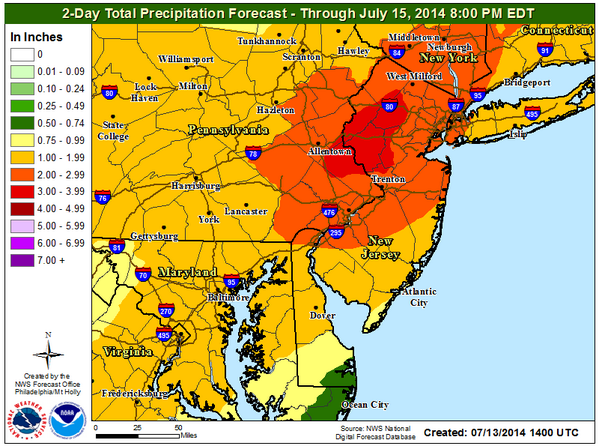
3+ inches of rain very possible over the next few days. We will begin that running total within the hour.
Yeah it's not 'technically' the polar vortex but bottom line is it's a unusually strong cool airmass dropping down from well up in Canada. Like i said the heart of it will hit the midwest but once the front goes through here we will flirt more with 80 than with 90 for a few days anyway.
Yeah Bryan we really can't complain about our weather so far this summer. It seemed we warmed gradually coming out of Spring and have been getting the moisture we need to avoid the lawns turning to hay like they usually do this time of year. Can only hope this pattern continues into all of August!!
I'd be ok with that Vic. A little heat to feel like summer is fine but not too much. We have had some dry stretches which i like too but then we get dumped on so overall that helps the plants, etc.
No big deal here in Oxford with that line of warned storms that moved through. Although the radar looked juiced..not much rain...wind... or anything else for that matter to report. Weird
I disagree with the "gradual warming" over the spring. It seemed as though it would never warm up, then when it finally did, we kept getting in the 8o's and 90's. It seemed as though we had far too few days in the 60's to mid 70's. The humidity and rain over the spring also seemed a bit much and the thunderstorms this year are driving my dog nuts. Any number count on that Bryan, especially since you live here in the H'cong, as I do?
Lost power 3 times again tonight, as the heavy thunderstorms drove through again, with everything rebooting just in time for the power to go out again. Of course I'd heard that the power restoration a year and a half ago was somewhat jury-rigged and not set for the long term so it makes me wonder how true that was. Of course that leaner phone pole near the intersection of Brooklyn Mt. and Durban roads may not be helping much either... .
Not sure of an exact # Phil. But it has gotten much more active in the last 2 weeks or so. It was pretty intense last night by me with wind, heavy rain and lightning.
8pm. Good. It'll be over before 24 starts. DirecTv flaked out last night during the premiere of The Strain.
I had the same issue with The Strain, emaxxman... luckily, FX aired the rerun directly afterwards.
heavy storms this afternoon,,,,,,,any comments???
just coach
There will be dark clouds, and a wet substance will fall from the sky. A noise similar to that of a bowling alley will be heard. Also yellow/gold streaks will highlight the sky
 Clyde Potts
 And a cat will be running a lap or two screaming about The Four Horsemen enroute to a hiding place behind the washer.
There will be dark butts..... SHOULD read dark butts. SORRY. See what happens when one tries to be a wise ass lol
Why when I key in the word CLOUD, it changes to butts? Is there someone messing around?
emaxx - Speaking of 24, can you find the thread? I tried searching and only an old one from 2010 came up. Wanted to see what everyone thought of the finale without derailing this thread.
it is too bad that you can't stick to the topic. bad weather warnings and alerts should be the only thing on a thunderstorm thread.
 fitter
  Spring Fever
A little rain..lasted about 5 minutes, but it's thundering right now in Lopatcong. I hope we get a nice down pour, the poor trees are thirsty.
 positive
 5catmom - I hate to say it, but catnip is exactly the way she behaves when she hears the thunder. On her back, then sprawled out in attack mode, then lashing out, claiming she sees Apocalyptic visions, then running away like crazy. Seriously, not too different from catnip. If you want to come be her therapist, be my guest. Meanwhile the rest of us just move out of her way. ;-)
That map indicates that there's about a 65% chance that temperatures will be below normal for the next 6-10 days? Is that extremely rare or something?
The map looks a lot different than it did an hour ago... now it has us at normal temperatures.
Define "early", mistergoogle (-;
No the map didn't change. It just shows that 75% of the county is likely to be below normal in the heart of summer next week. Pretty unusual.
It's just not like you to play straight man and serve up such a softball for one liner retorts.
The map DID change... when I first looked at it, our part of NJ was in the dark blue band, indicating a 60-70% probability of our temps being below normal. Now we're in the white, which means we will probably be right around normal.
Great sleeping weather for this time of year! Here were some low temps Friday morning:
Walpack - 45 degrees
Pequest - 48
Hope - 51
Hackettstown -55
it did change you're right sorry. They must of updated yesterday and the cooler temps (relatively) shifted south. Or at least the % of it happening did.
Thank you Bryan...now could you look into that big snake issue going on in another thread? Everyone trusts you...
Watch those open windows before going to bed tonight! :-)
Severe Thunderstorm Watches posted until 2AM:
http://forecast.weather.gov/showsigwx.php?warnzone=NJZ007&warncounty=NJC041&firewxzone=NJZ007&local_place1=Hope%20NJ&product1=Severe+Thunderstorm+Watch&lat=40.89595&lon=-74.96288#.U9WaO_ldWSo
Incoming..............special weather statement for folks in Washington (Warren County) and Oxford for that storm ianimal just got raked with down in Alpha:
http://forecast.weather.gov/showsigwx.php?warnzone=NJZ007&warncounty=NJC041&firewxzone=NJZ007&local_place1=2%20Miles%20WNW%20Vienna%20NJ&product1=Special+Weather+Statement&lat=40.88423&lon=-74.93322#.U9XAqvldWSo
Got 1 run of it here in Hopatcong earlier and an even worse bunch of Thunder & lightning just started a few minutes ago. The dogs been freaking out since around 9pm!
Yet another ho hum event where the radar looked worse than what was actually experienced here. Honestly, no complaining here in Oxford. Based on reports.... Alpha/Phillipsburg were hit hard on up into Harmony Twp with reports of wires down on the First Responder website. That storm either slid out of County or weakened as there are no reports of additional damage once you got north of Harmony earlier this evening per the First Responder website. JCP&L is still reporting some 3AM outage issues down in the Phillipsburg area at this early morning hour.
What a screwed-up forecast. Sunday was beautiful after about 11am. Weather forcasters need to get it together. ( not you Bryan)
Got a good 1/2" with decent thunder but nothing severe in Lk Hopat.
Agree, weekend forecasts were off. Saturday was mainly cloudy and Sunday was summery. It was supposed to be the opposite lol.
Really thought seething got hit by lightening last night here on the mountain in LV.
As for yesterday's forecast- glad it turned out so great. Went to the QC Festival of Ballooning and had great weather. I had packed rain ponchos but should have brought an umbrella for the sizzling sun..
Not thunderstorm related but are the temps really that far below average? There is about a 1/4 mile stretch on 78W (right before the toll) where the leaves on the trees are changing color already. It's not just a few leaves either. Some of it is whole trees have changed.
I'm not going to complain other than my pepper plants aren't doing well. I'll gladly take the electricity savings and lack of humidity though.
emaxxman
Temperature is not the reason leaves change color, it is the hours of the day light that prompts plants to prepare for winter.
No they are not really that far below average. We've had an unusual # of days in the 70s for July and a few nights way down in the 50s with even some 40s in spots. I'm not sure that would be enough to change the leaves. You see trees turn color the 2nd half of the summer more due to stress (hot/dry/etc) than anything. Overall i would say temps are just slightly below average for summer so far.
Yup, stress. Might be over-leafed as well. We have been losing lots of leaves all summer but trees are still full and not turning. A bit strange, but must be that they are so lush that some leaves must just have to go, so overpopulation stress.....
Interesting. You learn something new everyday. I always thought it was because of the colder temps.
I think colder temps (in fall) are definitely a big factor but the loss of daylight has a big effect too as citizen said.
bryan
temperatures have some affect color, but the amount light limits the amount of chlorophyll produced.

It's both the temp and the light and how it hits affects the vibrancy and which colors shine.
Here, more than you want to know: http://www.sciencebuff.org/collections/research-collections/botany/bright-fall-colors/
Although I think the colors are even a little brighter for Iman and his water pipe collection :>)
Just lost power here in Oxford at 12:51 AM for about 1 minute. Power back on but it's flickering again. Radar shows no storms in the area. Wonder what's up!
Yesterday was some of the most intense lightning I've ever seen! The rain was impressive, it just never stopped! Unfortunately ended up with some in the basement, but we're in between gutters right now while waiting for siding, so it's to be expected... We also lost power for a brief second coincidentally with a pretty large lightning strike, my wife thought we may have been hit for a second!
R u in Mansfield? I ask because I thought the same thing last night! I saw the bright flash, power went out and immediately thought that something nearby was hit. It was only out for a min or so though.
 Diamond Dweller
 Liberty, there were definitely a couple of strikes that hit pretty close nearby. Driving home down 80 around 7:30 and the amount of cloud to cloud lightning was incredible.
It was pretty bad in Oxford last night as well. Lots of lightning and thunder and tons of water.
According to my scaredy cat, the Four Horsemen of the Apocalypse rode once again and drove her behind the washing machine. ;-)
In our area of Independence; lots of heavy rain, thunder and lightening strikes not too far away. Our electricity went out for about 4 hours.
Yes definitely had some close calls with lightning strikes in Oxford last night! Most of the area did very well in the rain department as well. A MUCH needed soaking rain I might add. Yesterday's totals:
Hackettstown - 1.94 inches
Pequest - 1.33 inches
Hope - 1.01 inches
Local storm reports:
http://forecast.weather.gov/product.php?site=NWS&issuedby=PHI&product=LSR&format=TXT&version=1&glossary=0
There actually was a house stuck in Liberty last night around 9:30 in Danville Mountain Estates. The Mountain Lake fire department was there for a while.
 GMmom
GMmom I haven't had to mow in 3 weeks. That's a good thing but we did need the rain so i'll take it.
Well finally the advertised warmup is actually going to happen. But really it will only be around where it should normally be, maybe just a little above esp Weds.
After that it looks like the Hurricane should hook out to sea. Not much rain the forecast this week.
Somewhat of a pattern change is happening. Not sure yet if it will be long lasting or temporary. Obviously this week has gotten warmer but after a quick cold front, the general idea is at or above normal temps right into next week.
Seems like it's been a bit quiet on the t-storm front during the 2nd half of summer. Makes sense because there hasn't been any real drastic weather swings. But with all this humidity now and a cold front coming through this evening things should light up later today. Be on the lookout.
Of course, just when the schools get started and the sun is coming up later, the glare is horrible and you couldn't buy a cloud these days.
TIMING ~~ I love timing. If Bryan is not around, go to this website for dependable weather timings (and many other weather goodies).
This is for Andover NJ, but you can go to just about any selected area:
http://www.intellicast.com/Local/Hourly.aspx?location=USNJ0010
Generally after 2 with the highest chance after 5 or so. That's according to the NWS.
Drops already in Washington, headed for Hackettstown. Typical late afternoon behavior for late summer. Doesn't look good for folks at the Festival in the Borough.
Actually there is a pretty big break on the radar after what is coming through now passes. Should be ok for a few hours.
finally got a heavy rain with thunder and lightning - didn't last long enough but better than none--PV
Can't complain... thankfully didn't see any damage reports via the First Responder website with this evenings storms. I'll take my general half inch of rain for the lawns and gardens from tonight's cold frontal passage and be happy :-)
Much needed!
Enjoy the cooler and much less humid days and nights ahead!
We've had quite a stretch of fairly quiet weather. A cold front tonight has a decent chance to bring some stronger storms though.
The only warning I saw was in the Tuckerton NJ area just north of Atlantic City had a Tornado Warning very early Wednesday morning 1AM and it expired at 2AM. I checked some local reports later on in the morning and thankfully didn't see anything mentioned about damage.
http://www.nbcphiladelphia.com/news/local/Tornado-Warning-in-Parts-of-Ocean-County-New-Jersey-278479461.html
weather channel web site hourly forcast is T storms over a long period of time. Wonder what kind of storms are heading our way Wed To Thursday. Any idea???

Potential for a big show? Anyway, predicted 1.75" to 2" rain for us ... we could use it.
Since it's the time of year for superstitions, people used to put a single acorn on the windowsill for protection from lightning damage (ya never know).
Very scatt'd stuff for now. Later on it will get steadier and heavier. It's a slow mover so when the main band comes through it should be a few hours of heavy rain with a few storms embedded later tonight/very early tomorrow mainly.
I just bought new windshield wipers... I'll bet I don't see a drop the whole ride home (-;
Ick, so will it be a bad Thurs. morning commute or will it be out of here by 6 am?
Hoping that Route 80 construction zone in Parsippany doesn't get flooded out overnight! I have to navigate that area around 7AM tomorrow to get home from work.
Except for an eastbound left lane fender bender (Seems to be the norm there lately) it wasn't bad when I passed through there about an hour ago.
80 wasn't bad with flooding but the rain was very heavy between 6 and 6:30 am today (Thurs). It looks like the back end of the heavy rain is just about through now.
but for all the forcasts of thunderstorms, I didn't hear even one little boom. Looking at Bermuda tomorrow should be interesting. That hurricane looks strong. Hope everyone will be ok.
Commenting is no longer available.