History of Pequest River Flooding?
I drive Rt 46 along the Pequest River on an almost daily basis and it's been at it's highest and angryist I've seen it lately during my almost three years living in the area. It got me wondering about it's history. Do any long time locals know if it ever got so high to flood and close sections of Rt 46? It appears during the last few days that in some sections the water is lapping right at the highway's shoulder.
If so, does anyone have any old pics?
Thanks
Vic
 vic
vic Not sure about pictures, but this will get you to data from the early 80's not to mention, so coooooool. The gage has been there since 1929.
http://waterdata.usgs.gov/usa/nwis/uv?site_no=01445500
FYI --- highest was just a few years back I think when we hit two mega rains back to back within a 3-month or so period. Bryan can probably hit the date but Delaware came up to Route 80 twice and many river-side houses damaged.
 mistergoogle
 the Pequest river has ice dammed at least once and flooded out the sectionof rt 46 west of townsbury at least once in recent memory...its very high at this time but i have seen it flow higher
 oldman
 Down 46 near what used to be unclaimed freight (now a trucking company) about a mile from the rt 31 light is a notorious place for the pequest flooding
Interesting...I never knew Unclaimed Freight had a store on 46. The trucking company, would that be Lynch Trucking on Rt 46 just before Pequest Furnace Rd if you're going westbound? What is that large piece of fenced in property almost across the street from Lynch trucking? It looks like it served a purpose many years ago. It's directly at the corner of RT 46 & Pequest Furnace Road.

yes Unclaimed Freight had a store there for many years...the fenced in property you refer to across the road...was the former Peter Kero ashfalt plant...that made paving materials...before that it was an iron furnace...the Pequest Furnace
They "moved" pequest furnace road because it flooded out all the time. If you look close you can see where the old intersection with Rt46 was.. Right next to the river by the old RailRoad bridge
Was that an Erie Lackawanna Railroad ? Where was that track heading "to and from " ?
Thinking of the Pequest; Is that small private airport runway still along that lower section near the Pequest Creek ?
 BobR.
BobR. Oldman and Brad thanks for the pics and info. Oldman I knew you probably had an old pic up your sleeve! :-)
Bob, I noticed on Google Maps in the Great Meadows area it mentions an airport alongside the Pequest River called John E Rodgers Airport. The pic below is the approx area:
http://static.panoramio.com/photos/large/36135562.jpg
I find it hard to believe an airport ever existed there given how narrow it is...the River on one side...trees on the other.
Rogers had the trucking company right there and lived across from the runway. He used it for his private plane which he kept in the 'hangar' you see in the picture. Believe it had a smaller wingspan so he could take off and land there.
the airport you speak of is in Townsbury and needed a special short take off airplane to be used...i have not seen an airplane there in many years...although an airplane hangar...is still on the property...the railroads that were at the Pequest Furnace site...were the Erie Lackawanna railroad [ prior to being the Erie Lackawanna the railroad was built as the Warren railroad in 1853 and the railroad hauled coal and iron from NJ...to the NYC area]
and the Lehigh and Hudson River railroad...they interchanged at the Pequest site...the Erie Lackawanna railroad was abandoned in 1970...the Lehigh and Hudson river survived until 1986...when the tracks were removed...the Pequest Furnace opened in the 1870s...and closed and was demolished in 1903...oddly enough the road that crosses through the area still bears the name Pequest Furnace Rd...here is another picture of the Pequest furnace

here is another bit of history for you...it is a stock certificate...from the orginal Warren Rail-Road...the person featured on the certificate is John I Blair...a railroad builder and business man from Warren county...he later was one of the first members of the board of directors of the Union Pacific railroad...and supervised the construction of the trans-continental railroad...in 1869...the landscape picture is Delaware Water gap...looking west...because thats where he was building the Warren Railroad...to get to the coalfields of Pennsylvania...to move coal to the New York area...
mistergoogle says: Pequest means “open land," a corruption from two native dialects.
Either that or a "special" journey one takes on St. Patrick's Day....;>)
And to complete our river-ology, Musconetcong means “a rapid stream,” another native language corruption and amazingly linked to the same St. Paddies Day "special" journey.
Happy river walking for this beautiful day!
There appear to have been quite a few furnaces in our area. You mention the Pequest Furnace; wasn't there also an Oxford Furnace and an Andover Furnace ? The coal came from Pa., but where did all the iron come from in NW Jersey? There is bog iron in S. Jersey but I guess Warren County had iron deposits too. I did not realize that the Lehigh and Hudson railroad dipped down into the Htown region.

iron, magnetite and limestone and others.. Rockport, a port for rocks maybe....
Oxford furnace had some technical firsts as well unitl I think Phillipsburg overtook them.
http://books.google.com/books?id=kuoQAAAAIAAJ&pg=PA283&lpg=PA283&dq=rockport+nj+mines&source=bl&ots=9cOONIuZhK&sig=LmvcKsUFMcWfWuf6jsMLy3GHwxs&hl=en&ei=7XuHTdW5O5OcgQfPu5DDCA&sa=X&oi=book_result&ct=result&resnum=1&ved=0CBcQ6AEwAA#v=onepage&q=rockport%20nj%20mines&f=false
that rail line comes down from andover area and heads to belvidere then a long the delaware to p burg i can remember the trains runing on that line if look at that area higher up on that ridge you will see the other set of tracks that come from washington and go up to portland pa
 Caged Animal
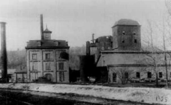
the Warren County area was laced with mines...Morris County also...Hackettstown had an iron furnace also...the iron furnace in Hackettstown closed around the same time as Pequest furnace... there was also an iron furnace in Stanhope Nj...i have enclosed a picture of the Hackettstown iron furnace as seen from the Morris Canal...in the backgound is Centenary college

Old Man,
Most of the mines n veins are labelled on the map jpg if u can enlarge it enough and yes, everywhere --- Shades, Catswamp, behind the church on Mt. Bethel. The Oxford mines were pretty extensive and ran some distance underground as shown in this jpg.
You gotta figure that the mine on Mt. Bethel Rd. supported a community large enough to build that church and graveyard. Not like you were going to horse n buggy it up those hills just for a good ole Sunday sermon. Which made me think --- where are the houses? The stores. There was a post office and school, all gone now. I guess miners dug rock all day, but built their town from wood, and I guess most didn't last after mining became unprofitable.
Note to ghosthunters, mines, graveyards, stone church with lots of quartz ---- wanna bet that one is haunted too..... I would love to sit in there one night with a group.
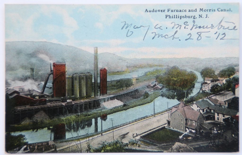
mistergoogle...you would love all the old mine maps i have...i come from a mining family...so i have been researching the mines in this area for many years...there was a Kishpaugh mine on Shades Of Death Rd also...there were mines in the vicinity of Marble Hill rd also...there were mines in Andover NJ...that used a mule railroad {the remains of which can still be seen along Waterloo rd }...that transported iron ore to Waterloo...to be loaded on canal boats...and shipped to the Andover Iron Mill...in Phillipsburg...here is a picture of the Andover Iron Mill...it was a very big operation for its time and was served by canal and rail
 maja
maja If you continue down rt 46..The delaware river likes to flood rt 46 just past rt 519 (king cole area)
oldman,
Thansk so much for posting this picture. My 11 yeard old does not believe me that this happened a few years back. I searched and searched for pictures but could never find any.
 KimS
KimS I have a bunch from 04, 05, and 06...I helped evacuate all along 46 in Knowlton. I have pics of us driving through some of the flooding in Columbia.
 John K
 Anybody have pictures of the houses floating down the Delaware? (it hit the freebridge in P'Burg)

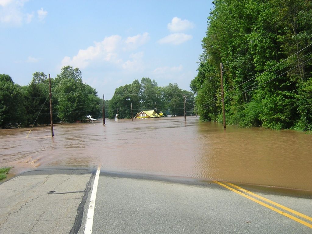
i dont have pictures of the house floating down the river...the Easton-Express Times published pictures of the i have this other picture from the same flood its the Knowlton Iron bridge...this should give you some idea how high the floodwaters were
All that ore mining in the hills around Htown is amazing. I wonder if any of the mining sites remain visible in some manner. When history of Htown area is discussed you never really hear too much about the mining past(at least I did not).
What is that exact location of the old Htown furnace. Centenary is in the distance and it was close to the canal, but where is that spot on the Morris Canal?
that picture of Hackettstown was taken from Mansfield twp...where the Morris canal runs close to Rockport rd...the Hackettstown furnace was located on Grande avenue...not far from the leather factory
Here's the Pequest Furnance, believe this is across from the Hatchery, looks like field to me.
"Below Great Meadows the river and Route 46 run side by side almost all the way to Belvidere where the Pequest joins the Delaware. Not too far after the highway and river join they pass through an agricultural area that is becoming residential. On the right hand side of the highway are some cleared fields that were occupied by the Pequest Iron Furnace, one of many furnaces in this area 120 years ago. Workers lived here and worked at the iron furnace, but today, the furnace and company houses have all disappeared."
Well, this probably wont' help but it was a 15 foot furnance located just above the Hatchery on Trout Brook. That's the one running down in the valley on Grand Ave.
as you head west on rt 46... turn left where the Kero asphalt plant formerly stood... you will be on Pequest Furnace road...follow this road to Pequest rd...turn right on Pequest rd...there is an unpaved parking area ahead on the left...park there and make your way to the abandoned railroad bed...follow the railroad bed a shortways west...and you will find an open area off to the right filled with piles of cinders...thats the remains of the Pequest furnace the Hackettstown Iron works were located just before Buck Hill rd..across the railroad tracks...the buildings were still there until the late 1970s...the twin Iron furnaces are along a brook that flows downhill from the Morris Canal
Well, so much for googling the Historic Register and Skyands history pages --- the Pequest location is a real difference --- different side of 46.......
tnks.
Check out the open pit mines, south of Airport Road past Walmarts. Very deep, filled with dark green water. Sorry area restricted by stone wall! A favorite place during the 30's to visit. Possability explored during WWII remining. Too expensive to try clear flooded mines. oldsoldier.
 oldsoldier
 As I child in WV, I and some friends rafted into a flooded mine. The entrances, even flooded, were large enough for the biggest trucks, the ceilings inside even larger. Off to the distance ---- three passageway entrances just as large but completely black as we paddled into the darkness.....
From the ceiling, a hole, a shaft of light penetrating the darkness, the beam piercing the black and hitting the water where it highlighted ......... a cross emanating like Excaliber from the Lady of the Lake's hand.
Then a loud crashing noice from above, breaking glass, metal, rock crashing down into the chamber behind us, the cross glowed in front of us, and beyond that --- three gateways to Hell..... OMG we are going to die..........Maaaaaammmmmmaaaaaaa
OK, hole in roof was the local hillybilly trash chute, cross was top of telephone pole, but us three boys in our raft ------- we were paddling to the sun making a three-foot wake paddling like we were the Roadrunner.....
No more mines, no caves, no tunnels.
Does anyone else remember swimming in the road on Mtn. Ave.(WHere all the fast food places and mall are now -I believe 1953)?All of us kids thought it was so cool and then we had to line up for "shots" at the Drs. office. It was actually deep enough to swim for the smaller kids (me at the time) about 6 years old at the time.. OH, WHAT A MEMORY!
 FRUSTRATED
 1953, swimming, and yet you can remember ---- anything.
Fantastic.
My hat's off to you!!!!! Give us your secret since I suffer from servere CRS and was not even on the planet n 1953.
I hear you!! Remember, as you age , you remember long ago and have trouble with the shortterm!! I don't know what I did yesterday! Seriously, I'm ONLY 64 - still young (in some ways). Actually, I remember it very well. I was swimming in front of the area that is now the main road in the Hong Kong Palace area! I believe we had had a Hurricane the night before-the roof blew off our house on Grand Ave. Sounds like a great week, hugh??
I would not doubt that I have times confused. However, I definitely remember the roof blowing off our house (have pictures) and I definitely remember swimming in the road (no pictures but I am sure I could find some = quite an event). They may have been different events but I believe they were in the approximate same time period and I know they both happened.Maybe oldman remembers? Do I now you "oldman"? Lived here my whole life and my parents before me (grandparents too)!
actually the river...has covered Mountain Ave...after 1953...but i would never have swum or waded in those floodwaters...i remember floods in others parts of Hackettstown...and the water was filthy...not like the water that usually runs in the river...
Frustrated
I was just kidding about me forgetting the last 5 minutes...... :>)
Commenting is no longer available.